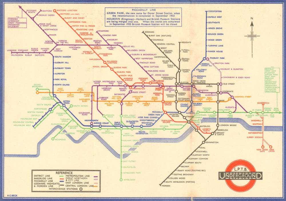
LONDON UNDERGROUND tube map plan diagram. 2nd HARRY BECK edition. August 1933
€1.397,95
SKU: P-6-018396
London Passenger Transport Board - Underground railways of London [no code] 1933
This, the second edition of the Underground map by H C Beck has the addition of a North compass pointer; there is a note about the change of station name from Dover Street to Green Park, on this version of the diagram Green Park is shown. The note also explains the merging of Holborn and British Museum Stations into one called Holborn (Kingsway), the new Station is also shown on the map. The logo on this version of the map has the initials LPTB printed above the UndergrounD bar on the roundel. "PICCADILLY LINE: GREEN PARK, the new name for Dover Street Station when the reconstruction is completed in September 1933. HOLBORN (Kingsway) - Holborn and British Museum Stations are being merged into one. When the works are completed in September 1933 British Museum Station will be closed (map)". There are numerous differences to today's network. Obviously the network has been much enlarged since the map was printed, however some stations shown on the map have closed or been renamed. These includes Marlboro Road station (between Swiss Cottage and St John's Wood) and Trafalgar Square have since closed, the South Acton spur closed in 1959, the Metropolitan Line beyond Amersham closed in 1961, the Middle Circle through Addison Road subsequently closed and much later reopened as part of the Overground. Name changes include Post office (today St Paul's), Queens Road (Queensway). The map includes the "Middle Circle", an underground train line using the West London Railway between Latimer Road and Earls Court, passing through Uxbridge Road and Addison Road. The line closed in 1940 following bomb damage. It was not reopened until 2008 as part of the Overground network.
Size 14 x 20 cm | 5.5 x 8.0 inches
Date Published: 1933 [no code, c. August 1933]
Type: Vintage diagram of lines pocket map issued by London Transport
Author: Beck, Harry C.
Publication: London Transport diagram of lines
Condition: Good |
Delivery & Returns
Packing
Items smaller than A4 size are usually packed in a stiffened, board-backed envelope. Larger items are rolled and packed in postal tubes. Large items which are too stiff to be rolled in wide-diameter tubes are mailed in all-board envelopes. In the unlikely event of damage in transit, please send the affected item or items back to us and we will provide a replacement or refund.
Delivery
Economy, tracked and express shipping options are available to all destinations worldwide. Over half our orders are sent to customers outside the United Kingdom and we have supplied over 30,000 buyers in over 70 different countries. We ship orders virtually every business day to customers in North America and Europe. The cost of delivery depends on the size of the largest item in your order, where you are located, and the delivery method that you choose at checkout. For orders received before 2pm, we can arrange delivery next day in the UK, within 2 business days to continental Europe and North America, and within 4 days to most other countries worldwide (excludes PO Box or APO/FPO (Military) addresses).
Returns
We accept returns for any reason if sent back to us within 14 days of receipt of your order. If any of your items are not as described, we will provide a full refund including reasonable return postage costs upon safe return to us. If you have changed your mind, you are responsible for the cost of returning the item to us. We describe the size, age and condition of all our products as fully and accurately as possible. Most of the items which we sell are in very good condition. However, the condition of antique and vintage prints and maps can vary. All of our product listings including a statement which classifies the condition as being either “Good”, “Fair”, or (rarely) “Poor” and which describes any material flaws, blemishes, imperfections or other significant features such as folds. Please read the description carefully before purchase.
Can we help? For more details or any questions.