
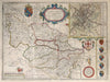
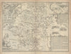
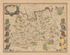
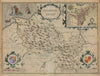
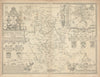
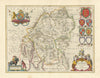
![Midle-sex [with] London & Westminster. John Speed county map. Overton 1710](http://www.antiquemapsandprints.com/cdn/shop/files/P-8-005948a_800933ce-152f-4b02-888c-2860759716b4.jpg?v=1753354614&width=3000)
![Midle-sex [with] London & Westminster. John Speed county map. Overton 1710](http://www.antiquemapsandprints.com/cdn/shop/files/P-8-005948a_800933ce-152f-4b02-888c-2860759716b4_100x100.jpg?v=1753354614)
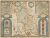
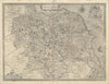
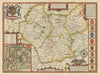
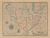
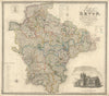
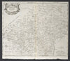
![Midle-sex [with] London & Westminster. Speed county map. Bassett & Chiswell 1676](http://www.antiquemapsandprints.com/cdn/shop/files/P-8-005947a_d6835bdb-bc05-4eb7-9635-a2fe3da32def.jpg?v=1753354614&width=3000)
![Midle-sex [with] London & Westminster. Speed county map. Bassett & Chiswell 1676](http://www.antiquemapsandprints.com/cdn/shop/files/P-8-005947a_d6835bdb-bc05-4eb7-9635-a2fe3da32def_100x100.jpg?v=1753354614)


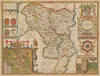


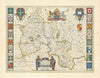


This collection brings together a rich variety of provincial and regional maps, spanning the counties of the British Isles, the states and territories of the United States, and the departments of France. Our British county maps cover England, Scotland, Ireland, and Wales and include over 60 cartographers such as John Speed, Joan Blaeu, Robert Morden, Thomas Moule, John Cary, and George Philip. Key sources include Camden’s Britannia, Theatre of the Empire of Great Britaine, Cary’s New Atlas, Britannia Depicta, Philip’s Handy Atlas, and Moule’s English Counties. Our extensive American holdings feature state and territorial maps from the 19th and 20th centuries by Colton, Johnson, Mitchell, Rand McNally, and Cram, as well as earlier works by Arrowsmith & Lewis, Cowperthwait, and Thomas. Notable examples include Walling & Gray’s Atlas of Massachusetts, pictorial maps by Taylor White and Liozu, and French-language editions by Buchon. Our French departmental maps are centred on 19th-century atlases by Vuillemin and Levasseur, known for their elegant engravings combining geography with economic, historical, and decorative detail. Major works include Nouvel Atlas Illustré, La France et ses Colonies, and Grand Atlas Départemental, supported by maps from Tardieu, Perrot, Dufour, and Malte-Brun.
EU orders up to €150 are sent VAT- and duty-paid — no additional taxes on arrival
Authenticity Guaranteed - We only sell original antique & vintage items
Can we help? Call us on +44-208-960-3476 • FAQs
All our products are exempt from US tariffs — no additional duties or taxes payable on arrival.
- Shop by Country
- Shop by Cartographer
- Shop Maps by Type
- Shop Prints by Subject