Hide out of stock items
EU orders up to €150 are sent VAT- and duty-paid — no additional taxes on arrival
Authenticity Guaranteed - We only sell original antique & vintage items
Can we help? Call us on +44-208-960-3476 • FAQs
All our products are exempt from US tariffs — no additional duties or taxes payable on arrival.
- Shop by Country
- Shop by Cartographer
- Shop Maps by Type
- Shop Prints by Subject


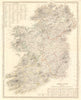
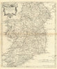
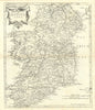
![Map of Dublin [for] Sinn Fein Rebellion Handbook. 1916 Easter Rising 1917](http://www.antiquemapsandprints.com/cdn/shop/files/P-6-111083a.jpg?v=1769108404&width=3000)
![Map of Dublin [for] Sinn Fein Rebellion Handbook. 1916 Easter Rising 1917](http://www.antiquemapsandprints.com/cdn/shop/files/P-6-111083a_100x100.jpg?v=1769108404)


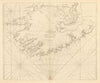


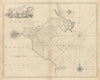


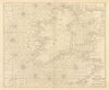
![A Chart of the Bay of Galloway [Galway] & River Shannon. MOUNT & PAGE 1758 map](http://www.antiquemapsandprints.com/cdn/shop/files/P-8-005213a_9567ff18-fe6f-4b37-8c4f-20e82a6fa6b1.jpg?v=1758196888&width=3000)
![A Chart of the Bay of Galloway [Galway] & River Shannon. MOUNT & PAGE 1758 map](http://www.antiquemapsandprints.com/cdn/shop/files/P-8-005213a_9567ff18-fe6f-4b37-8c4f-20e82a6fa6b1_100x100.jpg?v=1758196888)