
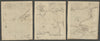

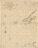

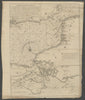

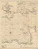
Edmond (or Edmund) Halley (1656-1742) was an English astronomer, mathematician and physicist. Best known for calculating the orbit of the eponymous Halley's Comet, he made also important contributions to cartography. In 1686 Halley became the first to depict trade winds and monsoons on a map, which appeared on his untitled diagrammatic world map, considered to be the first weather map and an early thematic map. Halley was granted temporary Captainship in the Royal Navy for his scientific voyage through the Atlantic on the ship Paramore, during which he investigated the laws governing the variation of the compass. He published his findings in General Chart of the Variation of the Compass (1701), a chart of the Atlantic ocean which was the first to use isogonic, or Halleyan, lines to show the pattern of magnetic variation, and is considered the earliest published isarithmic map of any kind. The following year Halley extended his chart to the western Pacific, using data from journals of voyages in the Indian Seas. He also surveyed the English Channel, published as A Large Chart of the Channell between England and France done from the newest and best surveys with the flowing of the tyde, and setting of the current, as they were observed in the year 1701. Published in 1702 this map, printed on three sheets, is the first to show the direction (indicated by arrows) and timing of the tides (indicated by Roman numerals). His final original contribution to cartography was a predictive map showing the path of the umbra cast over England by the Solar eclipse of May 3, 1715.
Last weekend for guaranteed pre Christmas delivery — order by 23 December with Special Delivery
EU orders up to €150 are sent VAT- and duty-paid — no additional charges on arrival
Authenticity Guaranteed - We only sell original antique & vintage items
Can we help? Call us on +44-208-960-3476 • FAQs
All our products are exempt from US tariffs — no additional duties or taxes payable on arrival.
- Shop by Country
- Shop by Cartographer
- Shop Maps by Type
- Shop Prints by Subject