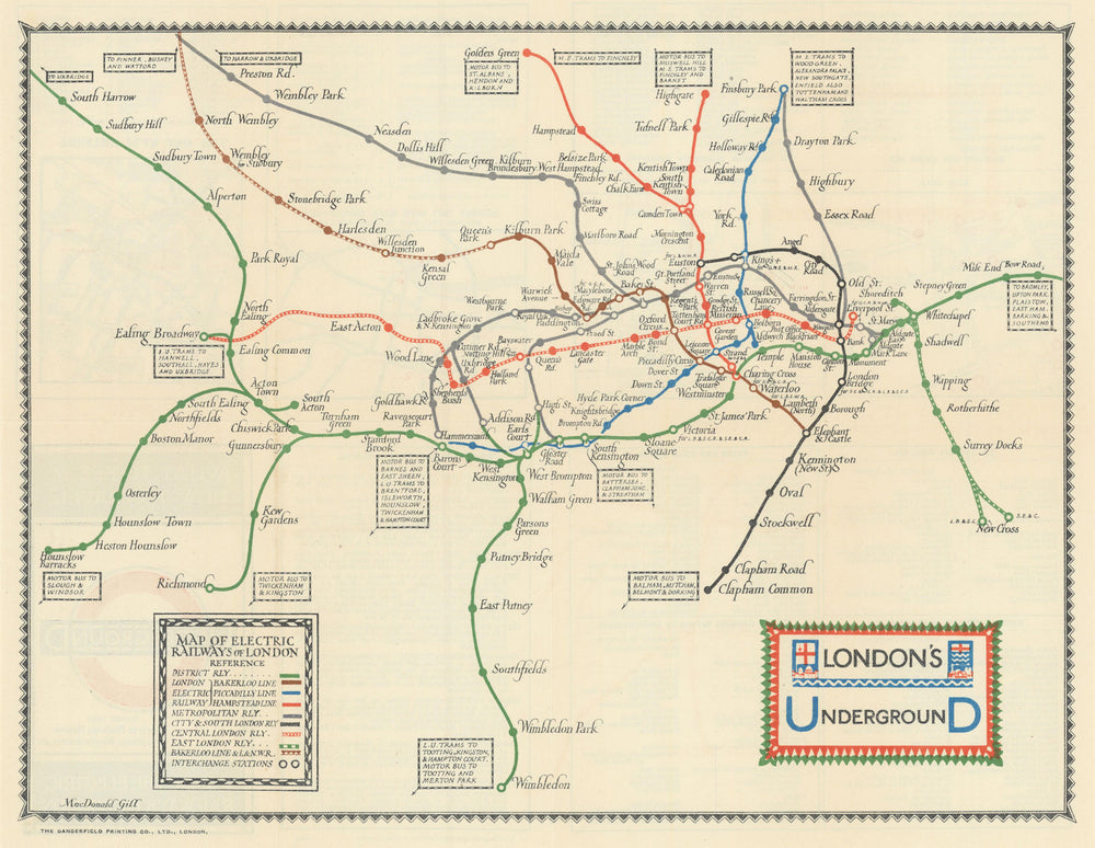
London's Underground. What to See/How to Travel. Macdonald Gill. March 1922 map
£580
SKU: P-6-107144
London's Underground - What to See and How to Travel - Map of the Electric Railways of London [Print code 1/3/22]
This is a paper edition of the geographic style Underground map. It shows all the Underground Group railways plus the Metropolitan Railway. The map shows all lines in their entirety except the Metropolitan line which is shown as far as Preston Road, the Bakerloo and L&NWR line to North Wembley and the District line as far as South Harrow in the West and Bow Road in the East, stations beyond the boundaries of the map are indicated in boxes at the end of the lines. Only six colours, green, blue, red, brown, grey and black, and various shading patterns, are used to represent the different lines. Connections to motor bus and tram services are given in a text box which points to the relevant Underground station. Interchanges are marked by circles and station names are all printed in black. There are no geographical features shown on this map. Extensions which are under construction are not shown, however the name of Notting Hill Station has been changed to Ladbroke Grove & North Kensington. This map has a black decorative border with the Underground logo as the title and a reference key at the bottom of the map. On the reverse there are details about main line connections, first and last trains, docks, markets, art galleries, academies, museums, public buildings, institutions, concert halls, parks, sports grounds, a street plan of the City and Kensington and a theatre plan and key. The front cover has an Underground roundel with a red circle and black UndergrounD logo bar.
Size 27 x 35 cm | 10.5 x 13.5 inches
Date Published: March 1922
Type: Antique London Underground folding system pocket map, issued to passengers
Author: Macdonald Gill, Leslie
Publication: London Underground Railways
Condition: Good |
Delivery & Returns
Packing
Items smaller than A4 size are usually packed in a stiffened, board-backed envelope. Larger items are rolled and packed in postal tubes. Large items which are too stiff to be rolled in wide-diameter tubes are mailed in all-board envelopes. In the unlikely event of damage in transit, please send the affected item or items back to us and we will provide a replacement or refund.
Delivery
Economy, tracked and express shipping options are available to all destinations worldwide. Over half our orders are sent to customers outside the United Kingdom and we have supplied over 30,000 buyers in over 70 different countries. We ship orders virtually every business day to customers in North America and Europe. The cost of delivery depends on the size of the largest item in your order, where you are located, and the delivery method that you choose at checkout. For orders received before 2pm, we can arrange delivery next day in the UK, within 2 business days to continental Europe and North America, and within 4 days to most other countries worldwide (excludes PO Box or APO/FPO (Military) addresses).
Returns
We accept returns for any reason if sent back to us within 14 days of receipt of your order. If any of your items are not as described, we will provide a full refund including reasonable return postage costs upon safe return to us. If you have changed your mind, you are responsible for the cost of returning the item to us. We describe the size, age and condition of all our products as fully and accurately as possible. Most of the items which we sell are in very good condition. However, the condition of antique and vintage prints and maps can vary. All of our product listings including a statement which classifies the condition as being either “Good”, “Fair”, or (rarely) “Poor” and which describes any material flaws, blemishes, imperfections or other significant features such as folds. Please read the description carefully before purchase.
Can we help? For more details or any questions.