Metropolitan Railway and Connections. London Underground. SELBIE c1930 old map
SKU: P-6-103817
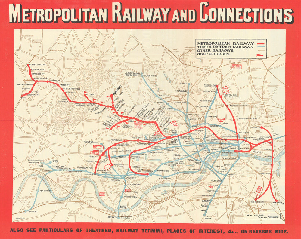
Metropolitan Railway and Connections [G.3583/100M]
Metropolitan Railway And Connections map; a folding geographic style map on paper, issued by the Metropolitan Railway. The map shows the Underground group lines overprinted in blue and the Metropolitan Railway in red with a red border. Stations are marked by circles, with only one circle used to represent an interchange between lines, station names are all printed in black. Most of the Metropolitan Railway is shown in its entirety, however it is not to scale with the rest of the lines, and the section to Verney Junction and Brill has been compressed in order to fit it onto the map. Some of the Underground lines are drawn in their entirety, some of the branch lines are ended prematurely, with an arrow used to indicate the continuation of a line. Down Street Station is still shown (closed 1932). Features such as exhibitions, football & cricket stadiums and greyhound tracks are marked in red, and roads, the River Thames and parks are also included. The Chiltern Hills have been drawn as a prominent feature on this map and the site of golf courses adjacent to the Metropolitan Railway have been indicated by a red flag symbol. Main line railways routes are marked with brown lines, however some of the lines are incomplete. On the reverse there are details about London theatres, shops and stores, main line railway connections, and places of interest. There are also descriptions and pictures of villages and towns served by the Metopolitan Railway, and information about how the Metro serves London. The front cover is red and has the Metropolitan Railway logo as a heading. The map is attributed to Robert Hope Selbie, who died in 1930. Lambeth (North) station appears without the brackets around the word North, which indicates that the map dates from no earlier than 1927, when the name of the station was changed.
Size 34 x 43 cm | 13.5 x 16.5 inches
Date Published: c.1930
Type: Antique London Underground system map
Author: Selbie, Robert Hope
Publication: Metropolitan Railway
Condition: Good |
Delivery & Returns
Packing
Items smaller than A4 size are usually packed in a stiffened, board-backed envelope. Larger items are rolled and packed in postal tubes. Large items which are too stiff to be rolled in wide-diameter tubes are mailed in all-board envelopes. In the unlikely event of damage in transit, please send the affected item or items back to us and we will provide a replacement or refund.
Delivery
Economy, tracked and express shipping options are available to all destinations worldwide. Over half our orders are sent to customers outside the United Kingdom and we have supplied over 30,000 buyers in over 70 different countries. We ship orders virtually every business day to customers in North America and Europe. The cost of delivery depends on the size of the largest item in your order, where you are located, and the delivery method that you choose at checkout. For orders received before 2pm, we can arrange delivery next day in the UK, within 2 business days to continental Europe and North America, and within 4 days to most other countries worldwide (excludes PO Box or APO/FPO (Military) addresses).
Returns
We accept returns for any reason if sent back to us within 14 days of receipt of your order. If any of your items are not as described, we will provide a full refund including reasonable return postage costs upon safe return to us. If you have changed your mind, you are responsible for the cost of returning the item to us. We describe the size, age and condition of all our products as fully and accurately as possible. Most of the items which we sell are in very good condition. However, the condition of antique and vintage prints and maps can vary. All of our product listings including a statement which classifies the condition as being either “Good”, “Fair”, or (rarely) “Poor” and which describes any material flaws, blemishes, imperfections or other significant features such as folds. Please read the description carefully before purchase.
Can we help? For more details or any questions.