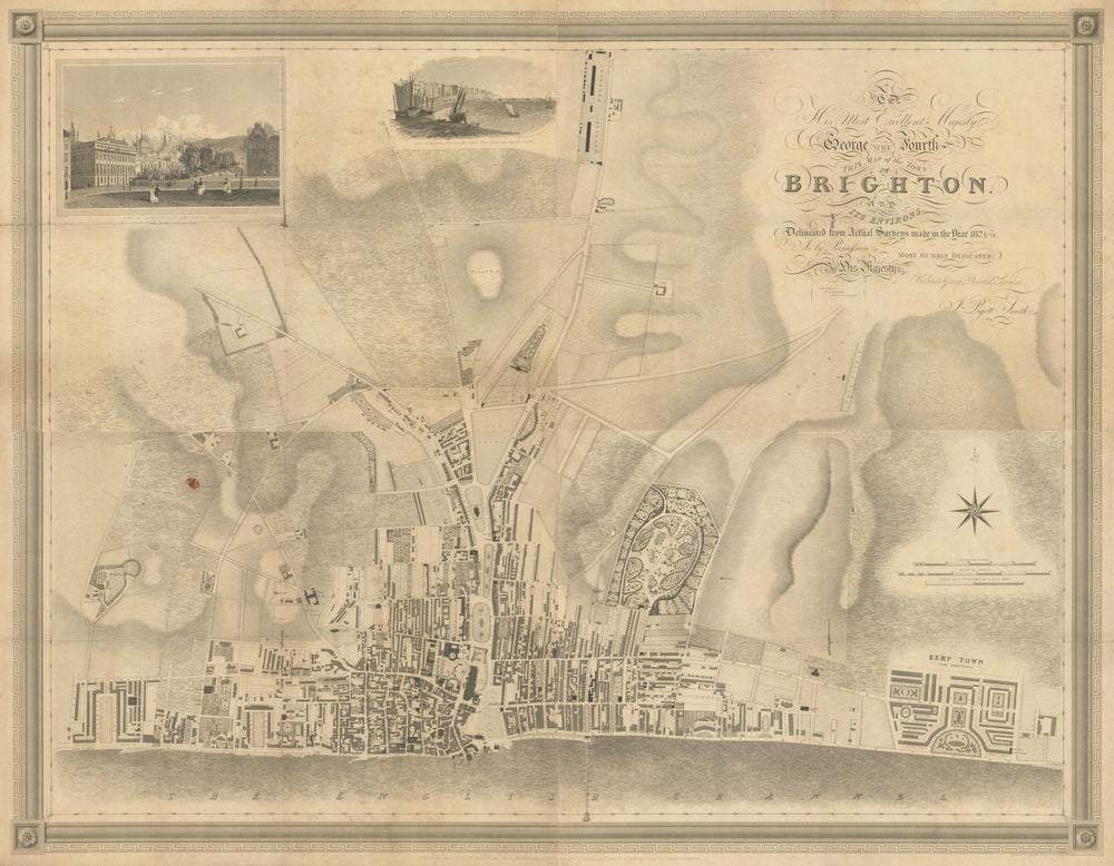
Brighton & its environs by J. Pigott-Smith. 4 sheets. 112x144cm. Scarce 1826 map
£1,860
SKU: P-9-000573
'To His Most Excellent Majesty George the Fourth, this map of the Town of Brighton and its environs, delineated from Actual Surveys made in the Year 1824-5, is by permission Most Humbly Dedicated, by His Majesty's Obedient & Very Devoted Servant, J. Pigott-Smith'
Large scale plan of Brighton by John Pigott-Smith; this map appears to be very scarce. Printed in 1826 on four sheets on a scale of 20 inches to one mile. The four sheets when joined will measure 112 x 144cm. The decorative title occupies about one third of the top right sheet, with each line is engraved in a different lettering. The map contains two vignette views: View of Brighton from the Albion Hotel [including the Royal Pavilion], and View of Marine Parade and Chain Pier from the Albion Hotel. Both the views are credited to J.P. Neale Delint; published for J.P. Smith. by Creasey & Baker, Gazette Office, Brighton. The map detail of the built up area extends from Brunswick Square to Kemptown, which at the date of survey was being built. To the north, the built up area only extends to short distance beyond St Peter's Church. The map extends inland about one and a half miles. At the top border is shown the Cavalry Barracks, (now Preston Barracks) on the Lewes Road.
Size 112 x 144 cm | 44.0 x 56.5 inches
Date Published: May 30th 1826
Type: Large linen-backed town plan of Brighton, on four sheets
Author: Pigott-Smith, John
Publication: Brighton and its environs
Condition: Good |
Delivery & Returns
Packing
Items smaller than A4 size are usually packed in a stiffened, board-backed envelope. Larger items are rolled and packed in postal tubes. Large items which are too stiff to be rolled in wide-diameter tubes are mailed in all-board envelopes. In the unlikely event of damage in transit, please send the affected item or items back to us and we will provide a replacement or refund.
Delivery
Economy, tracked and express shipping options are available to all destinations worldwide. Over half our orders are sent to customers outside the United Kingdom and we have supplied over 30,000 buyers in over 70 different countries. We ship orders virtually every business day to customers in North America and Europe. The cost of delivery depends on the size of the largest item in your order, where you are located, and the delivery method that you choose at checkout. For orders received before 2pm, we can arrange delivery next day in the UK, within 2 business days to continental Europe and North America, and within 4 days to most other countries worldwide (excludes PO Box or APO/FPO (Military) addresses).
Returns
We accept returns for any reason if sent back to us within 14 days of receipt of your order. If any of your items are not as described, we will provide a full refund including reasonable return postage costs upon safe return to us. If you have changed your mind, you are responsible for the cost of returning the item to us. We describe the size, age and condition of all our products as fully and accurately as possible. Most of the items which we sell are in very good condition. However, the condition of antique and vintage prints and maps can vary. All of our product listings including a statement which classifies the condition as being either “Good”, “Fair”, or (rarely) “Poor” and which describes any material flaws, blemishes, imperfections or other significant features such as folds. Please read the description carefully before purchase.
Can we help? For more details or any questions.