


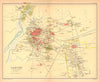


City plans of Bombay, Calcutta and Lahore, with their docks, cantonments and public buildings, stand out among these maps by John George Bartholomew (1860–1920), the Edinburgh cartographer whose family business supplied maps for atlases and reference books. The material here concentrates on British India in issues dated 1909–1931. Provincial sheets cover Rajputana, Hyderabad and the United Provinces, railway maps link them across the subcontinent, and thematic maps show languages and religions. Nepal, Tibet, Afghanistan and Aden are also covered, and the later issues carry his credit after his death.
EU orders up to €150 are sent VAT- and duty-paid — no additional taxes on arrival
Authenticity Guaranteed - We only sell original antique & vintage items
Can we help? Call us on +44-208-960-3476 • FAQs
All our products are exempt from US tariffs — no additional duties or taxes payable on arrival.


- Shop by Country
- Shop by Cartographer
- Shop Maps by Type
- Shop Prints by Subject