
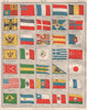
Quito's meridian and the Andean volcanoes give these maps of Ecuador a scientific as well as a political history, from the eighteenth century to the twentieth. Bellin's city and provincial plans show colonial Quito, while later maps place the country within Gran Colombia and then its national borders. Expedition diagrams, geological maps and disputed-frontier sheets connect the Andes with the Amazonian approaches, and the Galápagos Islands have atlas and anchorage maps of their own. The prints show Quito's buildings and inhabitants, Guayaquil's rafts and waterfront, volcanic scenery and the archaeological remains at Ingapirca and Cochasquí, with flag plates as well.
EU orders up to €150 are sent VAT- and duty-paid — no additional taxes on arrival
Authenticity Guaranteed - We only sell original antique & vintage items
Can we help? Call us on +44-208-960-3476 • FAQs
All our products are exempt from US tariffs — no additional duties or taxes payable on arrival.


- Shop by Country
- Shop by Cartographer
- Shop Maps by Type
- Shop Prints by Subject