


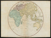


Large national surveys and sea charts give Faden's General Atlas an ambition far beyond a compact school atlas. William Faden's London business gathered work by several cartographers, among them Thomas Jefferys and Louis Stanislas de la Rochette, and the maps here are dated 1778 to 1806, each sheet with its own date and purpose rather than forming one survey. Britain, France, Germany, the Netherlands, Iberia and Italy appear alongside India and the hemispheres, coastal charts cover the Channel, the Bay of Biscay and the Mediterranean approaches, and political maps preserve revolutionary French divisions beside older European states.
EU orders up to €150 are sent VAT- and duty-paid — no additional taxes on arrival
Authenticity Guaranteed - We only sell original antique & vintage items
Can we help? Call us on +44-208-960-3476 • FAQs
All our products are exempt from US tariffs — no additional duties or taxes payable on arrival.


- Shop by Country
- Shop by Cartographer
- Shop Maps by Type
- Shop Prints by Subject