


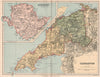


County geography and commercial information meet in the maps of Francis Sidney Weller, the late Victorian cartographer associated with William Mackenzie's Comprehensive Gazetteer of England and Wales. Most cover English and Welsh counties, with Yorkshire and Lancashire divided between sheets, paired counties and an inset of Anglesey, while town plans of Plymouth, Sheffield, Nottingham, Portsmouth and Gosport bring in an urban scale. Street's newspaper map plots where newspapers were published across England and Wales. Nigerian river maps show another side of his work, with survey credits separating the sources of the information from Weller's role in preparing the printed map.
EU orders up to €150 are sent VAT- and duty-paid — no additional taxes on arrival
Authenticity Guaranteed - We only sell original antique & vintage items
Can we help? Call us on +44-208-960-3476 • FAQs
All our products are exempt from US tariffs — no additional duties or taxes payable on arrival.


- Shop by Country
- Shop by Cartographer
- Shop Maps by Type
- Shop Prints by Subject