North America British possessions Canada Quadra/Vancouver Island LIZARS 1842 map
SKU: P-8-002247
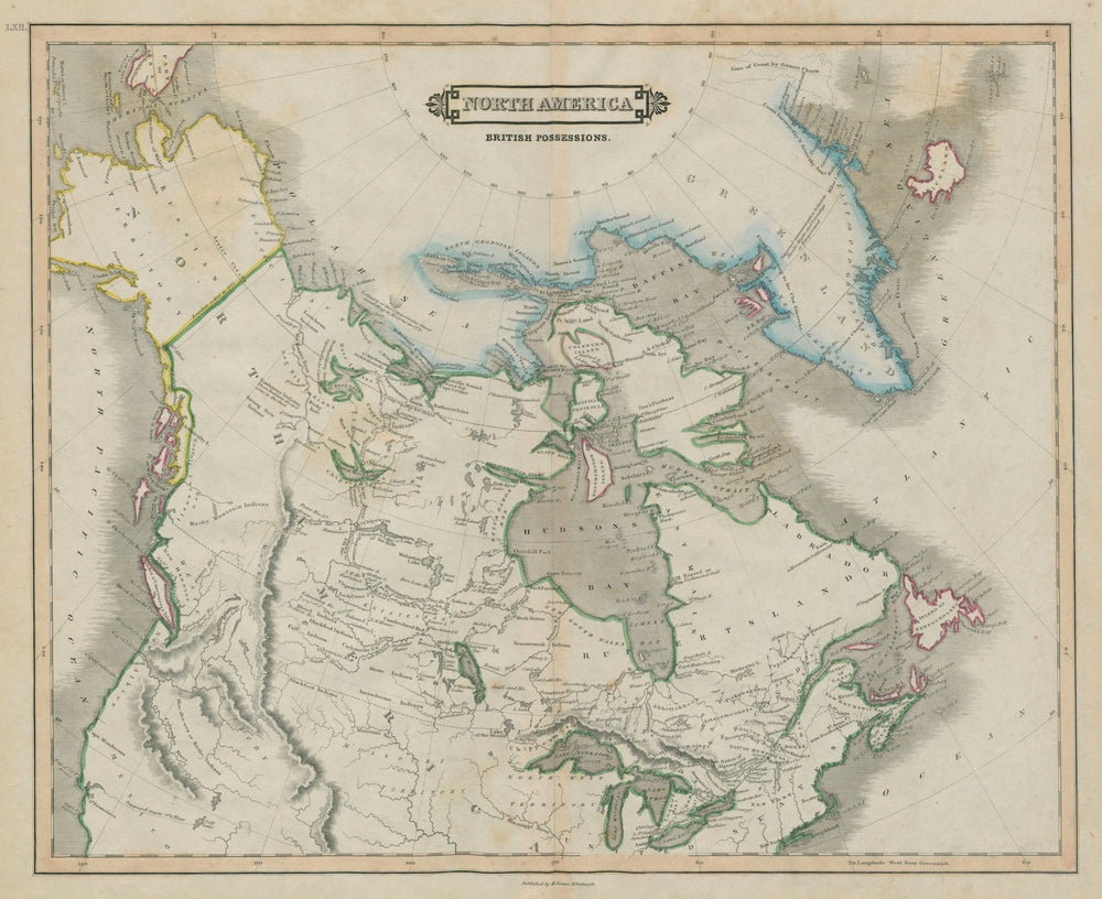
'North America British possessions'
Vancouver Island is marked with its original European name of "Quadra and Vancouver Island", reflecting the territorial claims at the time of both Spain and Great Britain; the British did not establish a colony on the island until 1843, shortly after publication of the map. Although not coloured, what was then the border between the United States and British North America (now Canada) is marked by a dotted line along the 49th parallel as far west as the Rocky Mountain, from there it follows the Rocky Mountains North to approximately the 54th parallel, including the southern part of the modern province of British Columbia. This reflected the US territorial claim of the time, while the British wanted a border that followed the Columbia River to the Pacific Ocean. This dispute was resolved in the Oregon Treaty of 1846, which established the 49th parallel as the boundary through the Rockies. That the border was not coloured on the map presumably reflected its unresolved nature at the time. The borders marked on the map also predate the Webster–Ashburton Treaty of 1842 which resolved the dispute known as the Aroostook War over the boundary between Maine on the one hand, and New Brunswick and the Province of Canada on the other. The treaty redefined the border between New Hampshire, Vermont, and New York on the one hand, and the Province of Canada on the other, resolving the Indian Stream dispute and the Fort Blunder dilemma at the outlet to Lake Champlain.
Size 45 x 55 cm | 17.5 x 21.5 inches
Date Published: 1842
Type: Antique 19th century atlas map with original hand colouring
Author: Lizars, William Home
Publication: Edinburgh Geographical General Atlas
Condition: Good |
Delivery & Returns
Packing
Items smaller than A4 size are usually packed in a stiffened, board-backed envelope. Larger items are rolled and packed in postal tubes. Large items which are too stiff to be rolled in wide-diameter tubes are mailed in all-board envelopes. In the unlikely event of damage in transit, please send the affected item or items back to us and we will provide a replacement or refund.
Delivery
Economy, tracked and express shipping options are available to all destinations worldwide. Over half our orders are sent to customers outside the United Kingdom and we have supplied over 30,000 buyers in over 70 different countries. We ship orders virtually every business day to customers in North America and Europe. The cost of delivery depends on the size of the largest item in your order, where you are located, and the delivery method that you choose at checkout. For orders received before 2pm, we can arrange delivery next day in the UK, within 2 business days to continental Europe and North America, and within 4 days to most other countries worldwide (excludes PO Box or APO/FPO (Military) addresses).
Returns
We accept returns for any reason if sent back to us within 14 days of receipt of your order. If any of your items are not as described, we will provide a full refund including reasonable return postage costs upon safe return to us. If you have changed your mind, you are responsible for the cost of returning the item to us. We describe the size, age and condition of all our products as fully and accurately as possible. Most of the items which we sell are in very good condition. However, the condition of antique and vintage prints and maps can vary. All of our product listings including a statement which classifies the condition as being either “Good”, “Fair”, or (rarely) “Poor” and which describes any material flaws, blemishes, imperfections or other significant features such as folds. Please read the description carefully before purchase.
Can we help? For more details or any questions.