Underground Map of London. Tube network. Print code 419-25000-3/4/24. April 1924
£640
SKU: P-6-107124
Underground Map of London [Print code 419-25000-3/4/24]
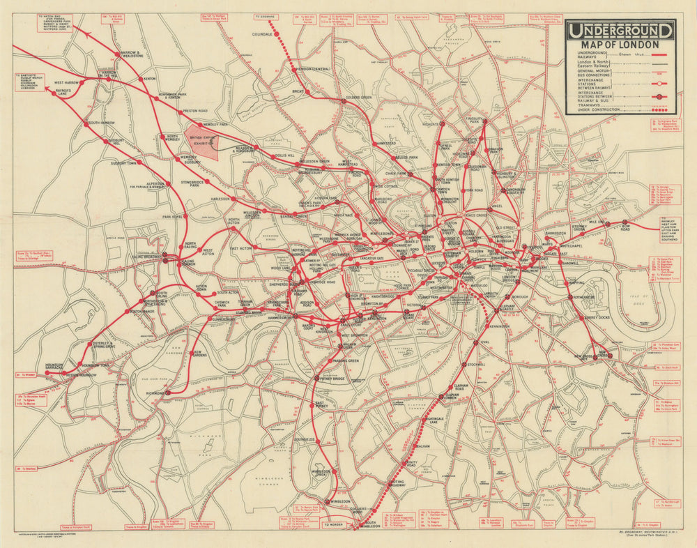
This is a paper edition of the geographic style Underground map. It shows all the Underground Group railways plus the Metropolitan Railway. All Underground lines are marked in red and the LNER line to the British Empire Exhibition at Wembley is marked with a thick grey line. Stations which are not covered within the boundary of the map are indicated by text boxes at the end of each line. Motor Bus and Tram routes are represented by thin red lines (tram lines are dashed), with the route number marked. Text boxes indicate the continuation of bus and tram lines beyond the border of the map. Geographical features such as roads, parks and rivers are shown in grey. Interchanges are marked by black circles with red crosses, but white line interconnectors are not used, station names are all printed in black. Railways under construction are represented as dotted lines, as used on the Hampstead & Highgate line between Charing Cross and Kennington, on the City & South London Railway extension to Morden, and the Hampstead and Highgate line extension to Edgware (Colindale Station opened August 1924). This map also marks the proposed joint extension of the Central London Railway and the LSWR between Shepherds Bush and Ravenscourt Park. City Road Station is no longer shown after its closure. South Kentish Town station is shown prior to its closure in June 1924. On the City & South London Railway (now Northern Line) under construction to Morden, the station south of Clapham Common - opened as Clapham South - is named as Nightingale Lane.
Select Option:
We have other examples of this item available. Explore them below to find the perfect one for you.
Size 35 x 45 cm | 14.0 x 17.5 inches
Date Published: April 1924
Type: Antique London Underground system map
Author: London Underground Railways
Publication: London Underground Railways
Condition: Good |
Delivery & Returns
Packing
Items smaller than A4 size are usually packed in a stiffened, board-backed envelope. Larger items are rolled and packed in postal tubes. Large items which are too stiff to be rolled in wide-diameter tubes are mailed in all-board envelopes. In the unlikely event of damage in transit, please send the affected item or items back to us and we will provide a replacement or refund.
Delivery
Economy, tracked and express shipping options are available to all destinations worldwide. Over half our orders are sent to customers outside the United Kingdom and we have supplied over 30,000 buyers in over 70 different countries. We ship orders virtually every business day to customers in North America and Europe. The cost of delivery depends on the size of the largest item in your order, where you are located, and the delivery method that you choose at checkout. For orders received before 2pm, we can arrange delivery next day in the UK, within 2 business days to continental Europe and North America, and within 4 days to most other countries worldwide (excludes PO Box or APO/FPO (Military) addresses).
Returns
We accept returns for any reason if sent back to us within 14 days of receipt of your order. If any of your items are not as described, we will provide a full refund including reasonable return postage costs upon safe return to us. If you have changed your mind, you are responsible for the cost of returning the item to us. We describe the size, age and condition of all our products as fully and accurately as possible. Most of the items which we sell are in very good condition. However, the condition of antique and vintage prints and maps can vary. All of our product listings including a statement which classifies the condition as being either “Good”, “Fair”, or (rarely) “Poor” and which describes any material flaws, blemishes, imperfections or other significant features such as folds. Please read the description carefully before purchase.
Can we help? For more details or any questions.