
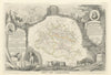


Pyrenean valleys, caves and small historic towns run through these maps and prints of Ariège. Departmental sheets by Levasseur, Vuillemin and others place Foix, Pamiers, Saint-Girons and Ax-les-Thermes in the mountainous country south of Toulouse, with inset town plans and resource maps adding detail, and the river Ariège draws the map northwards onto the Toulouse plain. The prints concentrate on river valleys, Saint-Lizier, mountain settlements and the approaches towards Andorra, while cave subjects reveal the limestone landscape below ground.
EU orders up to €150 are sent VAT- and duty-paid — no additional taxes on arrival
Authenticity Guaranteed - We only sell original antique & vintage items
Can we help? Call us on +44-208-960-3476 • FAQs
All our products are exempt from US tariffs — no additional duties or taxes payable on arrival.


- Shop by Country
- Shop by Cartographer
- Shop Maps by Type
- Shop Prints by Subject