


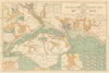
Beaulieu combines an abbey founded in 1204, a mill pond and a sheltered tidal river in the New Forest. Grose engraved the abbey and its great hall in 1776, and later prints show the abbey ruins, the village, Palace House, which incorporates part of the old monastic precinct, and the river at Buckler's Hard, with Ernest Haslehust's view of the mill pond from 1920. The maps place the village among Lyndhurst, Brockenhurst, Hythe and Southampton Water between 1906 and 1939. Charts follow the water to the Solent, from an 1885 sketch map of Southampton Water to Stanford's chart of 1932 and an Admiralty chart of the river and the Exbury coast from 1943, and a print of the same year shows the river entrance with its leading beacons.
EU orders up to €150 are sent VAT- and duty-paid — no additional taxes on arrival
Authenticity Guaranteed - We only sell original antique & vintage items
Can we help? Call us on +44-208-960-3476 • FAQs
All our products are exempt from US tariffs — no additional duties or taxes payable on arrival.


- Shop by Country
- Shop by Cartographer
- Shop Maps by Type
- Shop Prints by Subject