EU orders up to €150 are sent VAT- and duty-paid — no additional taxes on arrival
Authenticity Guaranteed - We only sell original antique & vintage items
Can we help? Call us on +44-208-960-3476 • FAQs
All our products are exempt from US tariffs — no additional duties or taxes payable on arrival.
- Shop by Country
- Shop by Cartographer
- Shop Maps by Type
- Shop Prints by Subject


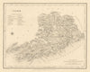

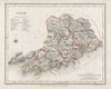


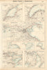


![#181 [Road from Cork to] Tralee and Killarney. Kerry. TAYLOR/SKINNER 1778 map](http://www.antiquemapsandprints.com/cdn/shop/files/P-6-105276a_33d65570-2121-42bf-9ca3-281ef3117179.jpg?v=1764869507&width=3000)
![#181 [Road from Cork to] Tralee and Killarney. Kerry. TAYLOR/SKINNER 1778 map](http://www.antiquemapsandprints.com/cdn/shop/files/P-6-105276a_33d65570-2121-42bf-9ca3-281ef3117179_100x100.jpg?v=1764869507)