


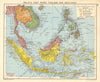


Island trading routes and Dutch colonial rule shape these maps of the East Indies, a historical name for the Malay and Indonesian archipelagos rather than any single modern country. Java, Sumatra, Borneo, Bali and the Moluccas appear in Dutch colonial mapping and broader atlases, some sheets reach into neighbouring parts of Southeast Asia, and plans of Batavia show the principal seat of administration. Nineteenth- and twentieth-century maps record resources, transport and travel under the boundaries and place names of their day. The prints add local scenes and portraits of governors-general of the Dutch East Indies, among them Van Goens, Van Hoorn and Van Cloon.
EU orders up to €150 are sent VAT- and duty-paid — no additional taxes on arrival
Authenticity Guaranteed - We only sell original antique & vintage items
Can we help? Call us on +44-208-960-3476 • FAQs
All our products are exempt from US tariffs — no additional duties or taxes payable on arrival.


- Shop by Country
- Shop by Cartographer
- Shop Maps by Type
- Shop Prints by Subject