
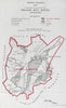


Holland is Lincolnshire's own low country, the flat fenland around Boston and the Wash, and one of the three historic Parts of the county with Lindsey and Kesteven. The sharpest focus comes from the Boundary Commission's map of 1917, which shows the parliamentary county of Holland with Boston. Philip's county map of 1902 marks the three Parts and their constituencies, a large sheet of 1903 carries the fens south into the Isle of Ely, and an 1893 map of eastern England reaches north to the Humber. Vintage maps of 1944, 1947 and 1952 still print the Parts of Lincolnshire beside the Ridings of Yorkshire.
EU orders up to €150 are sent VAT- and duty-paid — no additional taxes on arrival
Authenticity Guaranteed - We only sell original antique & vintage items
Can we help? Call us on +44-208-960-3476 • FAQs
All our products are exempt from US tariffs — no additional duties or taxes payable on arrival.


- Shop by Country
- Shop by Cartographer
- Shop Maps by Type
- Shop Prints by Subject