
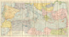


Steamship routes and inland excursions shape the maps from Mediterranean Seaports and Sea Routes, Baedeker's handbook of 1911 to the ports of the Mediterranean and Black Sea. Its coverage stretched to Madeira, the Canary Islands and the coasts of Morocco, Algeria and Tunisia, so Funchal and Las Palmas join Algiers, Tunis, Naples, Athens and Constantinople among the town plans. Plans of Carthage and Timgad lead beyond the harbours to archaeological sites, and other sheets reach Cairo and inland North African towns. Together they record the pre-war passenger's world, in which a coastal voyage could be combined with rail journeys and visits to classical monuments.
EU orders up to €150 are sent VAT- and duty-paid — no additional taxes on arrival
Authenticity Guaranteed - We only sell original antique & vintage items
Can we help? Call us on +44-208-960-3476 • FAQs
All our products are exempt from US tariffs — no additional duties or taxes payable on arrival.


- Shop by Country
- Shop by Cartographer
- Shop Maps by Type
- Shop Prints by Subject