
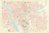


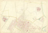


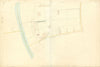


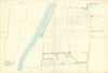


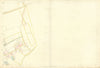
The Ordnance Survey Five-Foot-to-the-Mile Plan of the City of York, published under the supervision of Lieutenant Colonel Henry James R.E., Superintendent of the Ordnance Map Office, Southampton, is part of a remarkable series of highly detailed urban plans produced by the Ordnance Survey in the mid-19th century. Issued in 1852, this plan of York is drawn on an unusually large scale, allowing for the precise delineation of individual buildings, property boundaries, street furniture, and even garden features. The York plan was among the earliest in this elite series of town surveys, produced in response to public health concerns and the demands of urban administration following the Public Health Act of 1848. These maps offered an unparalleled record of the Victorian urban landscape. The Five-Foot Plan of York remains an essential resource for historians, archaeologists, and urban researchers, offering a snapshot of the city in extraordinary detail just before large-scale industrial and infrastructural transformations.
EU orders up to €150 are sent VAT- and duty-paid — no additional taxes on arrival
Authenticity Guaranteed - We only sell original antique & vintage items
Can we help? Call us on +44-208-960-3476 • FAQs
All our products are exempt from US tariffs — no additional duties or taxes payable on arrival.
- Shop by Country
- Shop by Cartographer
- Shop Maps by Type
- Shop Prints by Subject