
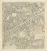


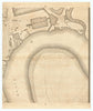


Richard Horwood’s survey of London is so detailed that individual buildings can be picked out among the densely packed streets and courts of the capital around 1800. His Plan of the Cities of London & Westminster covers Westminster, the City, Southwark and adjoining districts on sectional sheets that keep their original letter-and-number scheme, reaching west to Hyde Park and Marylebone, east to Whitechapel, Stepney, Bow and the docklands, and south to Lambeth and Kennington. The collection includes sheets associated with Horwood and later issues under Faden, which revised and extended the survey, and records London before much of the Victorian city took shape.
EU orders up to €150 are sent VAT- and duty-paid — no additional taxes on arrival
Authenticity Guaranteed - We only sell original antique & vintage items
Can we help? Call us on +44-208-960-3476 • FAQs
All our products are exempt from US tariffs — no additional duties or taxes payable on arrival.


- Shop by Country
- Shop by Cartographer
- Shop Maps by Type
- Shop Prints by Subject