
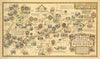

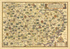


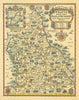

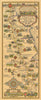
Colourful pictorial road maps made to sell petrol, these sheets from Pratts Petroleum Company turn a motor journey into a sequence of landmarks and local associations to look out for. Alfred Edward Taylor drew them for Pratt's High Test petrol, and the Anglo-American Oil Company published them between 1930 and 1933, when interwar motoring was growing and fuel companies used attractive maps to encourage travel and advertise their brands. The Bath Road and the Great North Road are drawn as linear routes, while broader sheets cover the Eastern Counties, the Midlands, northern England, the South Coast and Ireland.
EU orders up to €150 are sent VAT- and duty-paid — no additional taxes on arrival
Authenticity Guaranteed - We only sell original antique & vintage items
Can we help? Call us on +44-208-960-3476 • FAQs
All our products are exempt from US tariffs — no additional duties or taxes payable on arrival.


- Shop by Country
- Shop by Cartographer
- Shop Maps by Type
- Shop Prints by Subject