


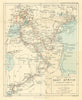




Rwanda's place in the Great Lakes region can be followed here from exploration maps through colonial tourism to later national geography. Scott Elliott's East African mapping and Hore's map of the Tanganyika basin sit beside wider sheets of Uganda and its neighbours. Mid-twentieth-century pictorial maps by Josse Léonard and James Thiriar include Ruanda-Urundi in a promoted Congo travel circuit, and later maps turn to the economy, agriculture and resources. Flag plates record different periods of the state's history.
EU orders up to €150 are sent VAT- and duty-paid — no additional taxes on arrival
Authenticity Guaranteed - We only sell original antique & vintage items
Can we help? Call us on +44-208-960-3476 • FAQs
All our products are exempt from US tariffs — no additional duties or taxes payable on arrival.


- Shop by Country
- Shop by Cartographer
- Shop Maps by Type
- Shop Prints by Subject