
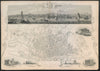

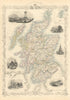

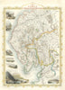

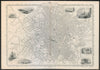

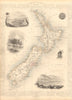

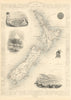

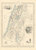


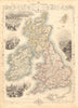

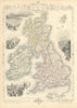


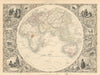

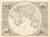


Tallis’s Illustrated Atlas, and Modern History of the World, issued in London and New York by John Tallis & Co. to coincide with the 1851 Great Exhibition, is the last great decorative atlas of the nineteenth century. Edited by R. Montgomery Martin, with maps chiefly engraved by John Rapkin, it presented a global survey at the height of Britain’s imperial and commercial confidence. Its distinctive appeal lies in the finely engraved maps, elaborate borders, armorial devices and pictorial vignettes showing cities, peoples, monuments, shipping and natural scenery. Combining geographical information with visual spectacle, the atlas ranges across the continents, nations, colonies, American states and British regions, making it both an important cartographic record and a highly decorative publishing achievement.
EU orders up to €150 are sent VAT- and duty-paid — no additional taxes on arrival
Authenticity Guaranteed - We only sell original antique & vintage items
Can we help? Call us on +44-208-960-3476 • FAQs
All our products are exempt from US tariffs — no additional duties or taxes payable on arrival.
- Shop by Country
- Shop by Cartographer
- Shop Maps by Type
- Shop Prints by Subject