Hide out of stock items

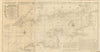


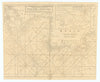


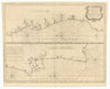
![A Chart of the Sea Coasts of Algrave [Algarve] & Andalusia MOUNT & PAGE 1758 map](http://www.antiquemapsandprints.com/cdn/shop/files/P-8-005239a_35fae78c-6bee-491b-9205-b907179915f0.jpg?v=1758196909&width=3000)
![A Chart of the Sea Coasts of Algrave [Algarve] & Andalusia MOUNT & PAGE 1758 map](http://www.antiquemapsandprints.com/cdn/shop/files/P-8-005239a_35fae78c-6bee-491b-9205-b907179915f0_100x100.jpg?v=1758196909)


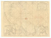
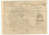
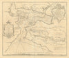
![The Sea Coast of France from Ushent to Olone [Olonne]. MOUNT & PAGE 1758 map](http://www.antiquemapsandprints.com/cdn/shop/files/P-8-005222a.jpg?v=1758196888&width=3000)
![The Sea Coast of France from Ushent to Olone [Olonne]. MOUNT & PAGE 1758 map](http://www.antiquemapsandprints.com/cdn/shop/files/P-8-005222a_100x100.jpg?v=1758196888)

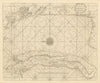


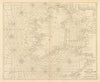
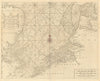
![Antique sea 'Chart of the Islands of Cape Verd' [Verde]. MOUNT & PAGE 1758 map](http://www.antiquemapsandprints.com/cdn/shop/files/P-8-005244a.jpg?v=1758196908&width=3000)
![Antique sea 'Chart of the Islands of Cape Verd' [Verde]. MOUNT & PAGE 1758 map](http://www.antiquemapsandprints.com/cdn/shop/files/P-8-005244a_100x100.jpg?v=1758196908)


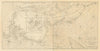
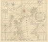
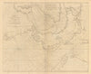
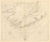
![A Chart of the Bay of Galloway [Galway] & River Shannon. MOUNT & PAGE 1758 map](http://www.antiquemapsandprints.com/cdn/shop/files/P-8-005213a_9567ff18-fe6f-4b37-8c4f-20e82a6fa6b1.jpg?v=1758196888&width=3000)
![A Chart of the Bay of Galloway [Galway] & River Shannon. MOUNT & PAGE 1758 map](http://www.antiquemapsandprints.com/cdn/shop/files/P-8-005213a_9567ff18-fe6f-4b37-8c4f-20e82a6fa6b1_100x100.jpg?v=1758196888)


Maps from "The English Pilot - Part I, describing the sea-coasts, capes, headlands, bays, roads, harbours, rivers and ports. Together with the soundings, sands, rocks and dangers in the Southern Navigation upon the coasts of England, Scotland, Ireland, Holland, Flanders, Spain, Portugal, to the Streights-Mouth; with the Coasts of Barbary, and off to the Canary, Madera, Cape de Verde and Western Islands shewing the courses and distances, from one place to another. The setting of the tides and currents. The ebbing and flowing of the sea &c.", London, printed for W. and J. Mount and T. Page, at the Postern on Tower-Hill, MDCCXLIX (1747-1758)