Great Britain's Coasting Pilot
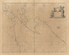
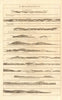
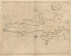
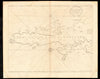
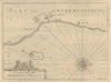
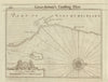
Captain Greenvile Collins’s Great Britain’s Coasting Pilot, first published in 1693, was the first systematic maritime survey of the British coastline based on direct observation rather than compiled reports. Commissioned by King Charles II and executed under the Royal Navy’s authority, Collins—appointed Hydrographer in Ordinary to the King—personally surveyed the coasts of England, Scotland, and the islands from the Thames to the Orkneys and Shetlands. The Pilot includes detailed sea charts, harbour plans, and extensive sailing directions covering tides, depths, bearings, sea-marks, and coastal features. It was reissued in expanded and corrected editions in 1702, 1723, 1753 and beyond, each incorporating updates reflecting changing navigational needs and coastal developments. The work was a landmark in British hydrography, combining technical precision with elegant engraving, and remained a standard reference for navigators and maritime authorities throughout the 18th century.