


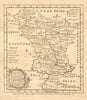


Emanuel Bowen’s compact county maps appeared between 1757 and 1761 in The General Magazine of Arts & Sciences, where geography took its place among the useful knowledge offered to mid-eighteenth-century readers. Published in London by W. Owen, they cover Middlesex, Buckinghamshire, Northamptonshire, Staffordshire and Derbyshire, with a chart of the Strait of Gibraltar taking the reader to southern Europe. The Middlesex sheet includes London, Westminster and Southwark.
EU orders up to €150 are sent VAT- and duty-paid — no additional taxes on arrival
Authenticity Guaranteed - We only sell original antique & vintage items
Can we help? Call us on +44-208-960-3476 • FAQs
All our products are exempt from US tariffs — no additional duties or taxes payable on arrival.


- Shop by Country
- Shop by Cartographer
- Shop Maps by Type
- Shop Prints by Subject