


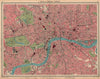


Original 1930s–1940s maps covering Paddington, Bayswater and neighbouring streets, from compact street plans to large folding sheets. Highlights include the London School of Economics’ 1930 social-survey maps, Bartholomew’s 1939 central London plan and a detailed German military map of 1940. Selected 1955 Paddington Estate auction plans add close views of Royal Oak, Westbourne Grove, Paddington Green, Lancaster Gate and Queensway, with original auction particulars where specified.
EU orders up to €150 are sent VAT- and duty-paid — no additional taxes on arrival
Authenticity Guaranteed - We only sell original antique & vintage items
Can we help? Call us on +44-208-960-3476 • FAQs
All our products are exempt from US tariffs — no additional duties or taxes payable on arrival.


- Shop by Country
- Shop by Cartographer
- Shop Maps by Type
- Shop Prints by Subject