


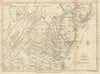


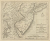


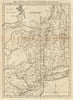


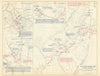


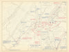


Our American War of Independence collection presents a vivid cartographic history of the conflict that shaped the United States. Spanning key regions—from Boston and New York to the Carolinas and Virginia—these maps document troop movements, battle sites, fortifications, and colonial settlements during the struggle for independence. The collection includes works by John Hancock, Charles Stedman, and John Lodge, alongside period sources such as Gentleman’s Magazine, Political Magazine, and Universal Magazine. Several items are drawn from The West Point Atlas of American Wars and The History of the Origin, Progress & Termination of the American War, offering military and historical context. Maps cover both northern and southern campaigns, with state-level detail for Massachusetts, New Jersey, Pennsylvania, the Carolinas, and Georgia, among others. British and American perspectives are both represented. With a mix of official publications and anonymously produced wartime maps, this archive provides an essential resource for historians, collectors, and anyone fascinated by the geography of revolution.
EU orders up to €150 are sent VAT- and duty-paid — no additional taxes on arrival
Authenticity Guaranteed - We only sell original antique & vintage items
Can we help? Call us on +44-208-960-3476 • FAQs
All our products are exempt from US tariffs — no additional duties or taxes payable on arrival.
- Shop by Country
- Shop by Cartographer
- Shop Maps by Type
- Shop Prints by Subject