
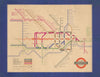

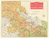

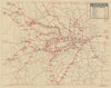

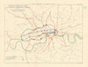

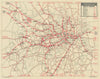


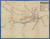


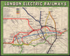

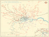

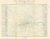

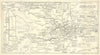

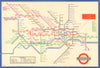

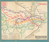


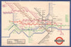

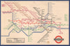

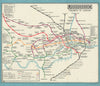

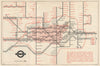

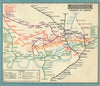

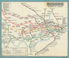

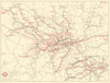


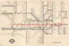


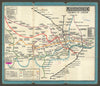

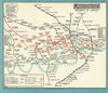
The London Underground map has evolved from a patchwork of geographically accurate plans produced by competing private railways in the late 19th century. A more unified approach emerged under the Underground Electric Railways Company of London (UERL), led by Frank Pick, who championed consistent design and clear passenger information. In 1914, MacDonald Gill created the whimsical “Wonderground” map, helping embed the Tube in London’s cultural identity. During the 1920s Frederick Stingemore introduced compact pocket maps with simplified, though still geographic, layouts. In 1931, Harry Beck, inspired by electrical diagrams, proposed his radical — and now iconic — diagrammatic map using only 45- and 90-degree angles. Published in 1933, it was immediately popular and laid the foundation for modern transit mapping. Beck refined his design into the 1940s, though during the war years, the map briefly took a new direction under Hans “Zero” Schleger. In 1960, Harold Hutchinson introduced a more angular — but less popular — version. Later adaptations by Paul Garbutt and others continued to evolve the map for a growing network. Today, it remains a global design icon, rooted in Beck’s vision and shaped by successive hands.
EU orders up to €150 are sent VAT- and duty-paid — no additional taxes on arrival
Authenticity Guaranteed - We only sell original antique & vintage items
Can we help? Call us on +44-208-960-3476 • FAQs
All our products are exempt from US tariffs — no additional duties or taxes payable on arrival.
- Shop by Country
- Shop by Cartographer
- Shop Maps by Type
- Shop Prints by Subject