
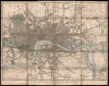


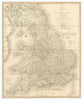


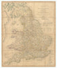

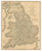

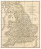

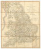

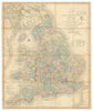

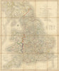

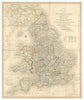


John Cary (c.1754–1835) was an English cartographer, engraver, globe maker and publisher known for his clear, high-quality maps. His work included county, canal, highway, celestial, and topographical maps, including those of London and its environs. We stock maps from his New and Correct English Atlas (1787), Traveller's Companion (1790–1828), New Map of England & Wales (1794), and his Survey of the Country 15 Miles Around London (1786), among others. Cary responded to rising demand for accurate road maps in the late 18th century. His Traveller’s Companion, based on a new survey commissioned by the Postmaster General, featured the so-called Cary miniature county maps. The project was influential in the development of the Ordnance Survey (est. 1791), and distances were measured using a hand-pushed four-foot wheel counter. Cary began as an apprentice to William Palmer in 1770 and opened his own business in 1783. His maps and globes soon earned a strong reputation. The New Itinerary (1798) mapped major roads across England and Wales, and Cary also produced early Ordnance Survey maps before 1805. The business passed to his sons and was later taken over by G. F. Cruchley in 1844, with Cary’s plates reused well into the 19th and even 20th century.
EU orders up to €150 are sent VAT- and duty-paid — no additional taxes on arrival
Authenticity Guaranteed - We only sell original antique & vintage items
Can we help? Call us on +44-208-960-3476 • FAQs
All our products are exempt from US tariffs — no additional duties or taxes payable on arrival.
- Shop by Country
- Shop by Cartographer
- Shop Maps by Type
- Shop Prints by Subject