
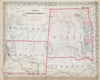


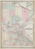

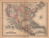

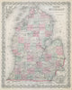

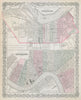

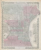

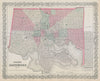


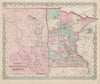

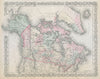

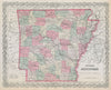

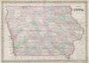


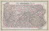

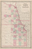

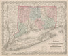

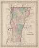

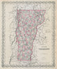

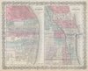

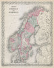


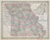


J.H. Colton (1800–1893) was one of the most influential American map publishers of the 19th century, active from 1831 to 1890. Based in New York, he began by licensing maps from other cartographers but soon developed a distinctive house style. His work is noted for a recognisably American mid-19th century aesthetic: fine steelplate engraving, rich hand colouring in a distinctive palette, and ornate decorative borders. Colton’s firm played a pivotal role in documenting the dramatic transformation of the United States during a period of rapid territorial expansion—following the Louisiana Purchase, the annexation of Texas, the Mexican–American War, and the admission of new states. His Atlas of the World (1855–56) and the widely circulated General Atlas (1857–88) recorded these changes in near real time, frequently updating county lines, political boundaries, and railroads. Particularly notable are Colton’s maps of the Trans-Mississippi West—depicting evolving territories like Kansas, Nebraska, Indian Territory, Utah, and New Mexico—where borders shifted amid migration, conflict, and development. His Condensed Octavo Atlas of the Union (1864), published during the Civil War, captured a nation still defining its political and physical identity. Today, his maps are valued both for their beauty and as vivid historical records of a continent in flux.
EU orders up to €150 are sent VAT- and duty-paid — no additional taxes on arrival
Authenticity Guaranteed - We only sell original antique & vintage items
Can we help? Call us on +44-208-960-3476 • FAQs
All our products are exempt from US tariffs — no additional duties or taxes payable on arrival.
- Shop by Country
- Shop by Cartographer
- Shop Maps by Type
- Shop Prints by Subject