


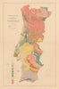


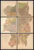


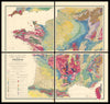


Geological maps combine scientific precision with a vibrant visual aesthetic, offering layered insights into the structure of the earth beneath our feet. Their vivid colour-coding, intricate textures, and complex legends make them enchanting visual artefacts. Our stock, much of which was purchased from the Natural History Museum, spans over two centuries of geological cartography, from foundational surveys by the Geological Survey of Great Britain and Stanford, to richly detailed regional studies by Franz Beyschlag, George Ferdinand Becker, and the Geological Survey of Victoria. These maps capture changing theories of the earth’s formation, early mining ventures, and imperial surveying, and range from large-scale national sheets to rare early field surveys and folded atlas plates. Notable figures such as Antisell, Capellini, Sederholm, and von Hauer are represented, as are important institutions like the US Geological Survey, British Geological Survey, and k.k. Geologische Reichsanstalt. Whether admired for their technical achievement, aesthetic appeal, or historical significance, geological maps continue to fascinate collectors, scientists, and designers alike — as enduring testaments to how we visualise and measure the deep time of the planet.
EU orders up to €150 are sent VAT- and duty-paid — no additional taxes on arrival
Authenticity Guaranteed - We only sell original antique & vintage items
Can we help? Call us on +44-208-960-3476 • FAQs
All our products are exempt from US tariffs — no additional duties or taxes payable on arrival.
- Shop by Country
- Shop by Cartographer
- Shop Maps by Type
- Shop Prints by Subject