


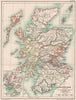


The continent is redrawn period by period, from late Roman provinces to the partitions of Poland, in maps from Historical Atlas of Modern Europe, Reginald Lane Poole's atlas published by Henry Frowde in London in 1902. Migrations lead into medieval kingdoms, ecclesiastical divisions and the growth of European states. British subjects include Domesday England, medieval Scotland, Irish plantations and parliamentary representation, and continental sheets cover the Italian city states, Germany in the Reformation and the Thirty Years' War, and French acquisitions. Maps of India, Abbasid western Asia and overseas colonies extend the story beyond Europe, with insets and period names throughout.
EU orders up to €150 are sent VAT- and duty-paid — no additional taxes on arrival
Authenticity Guaranteed - We only sell original antique & vintage items
Can we help? Call us on +44-208-960-3476 • FAQs
All our products are exempt from US tariffs — no additional duties or taxes payable on arrival.


- Shop by Country
- Shop by Cartographer
- Shop Maps by Type
- Shop Prints by Subject