
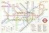

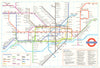

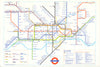

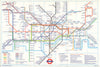

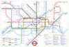

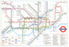

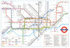

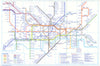

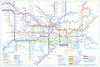

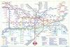

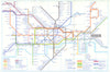

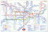

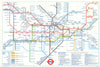

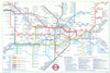

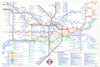

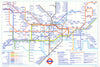

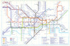

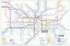

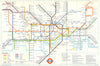

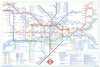

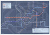

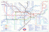

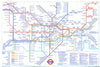

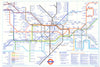

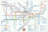

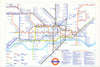

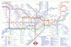

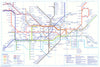

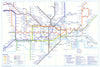

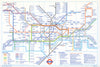

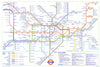

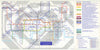

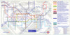

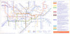

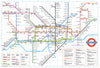

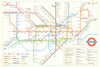
Many public transport maps issued by London Transport, Transport for London (TfL) and its predecessors were collaborative or in-house productions and remain unattributed to individual cartographers or designers. These institutional works reflect the evolving identity of London’s transport system over more than 90 years. The London Passenger Transport Board (LPTB), founded in 1933, unified the capital’s Underground, bus, tram, and trolleybus services. Though operating independently of direct government control, it branded itself as “London Transport” and introduced consistent graphic standards, including the Johnston typeface and modern mapping conventions. Following nationalisation in 1948, the LPTB became the London Transport Executive (LTE) under the British Transport Commission, overseeing the post-war transition from trams to buses. In 1963, LTE was replaced by the London Transport Board, and in 1970, control passed to the Greater London Council, introducing regional political oversight. With the creation of the Greater London Authority in 2000, TfL was established, reporting to the Mayor of London. It now operates the city’s buses, Underground, Overground, and more. While the “London Transport” name has become a legacy brand, the maps issued by these public bodies—often anonymous—continue to shape how Londoners and visitors navigate the capital.
EU orders up to €150 are sent VAT- and duty-paid — no additional taxes on arrival
Authenticity Guaranteed - We only sell original antique & vintage items
Can we help? Call us on +44-208-960-3476 • FAQs
All our products are exempt from US tariffs — no additional duties or taxes payable on arrival.
- Shop by Country
- Shop by Cartographer
- Shop Maps by Type
- Shop Prints by Subject