


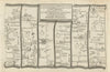


Border roads and the market towns along the Severn give these antique maps of Shropshire their character, with county sheets by Morden, Cary, Moule, Bacon and Philip and road strips through Shrewsbury, Ludlow, Bridgnorth and Much Wenlock. Route maps running on towards Welshpool and the Welsh interior show the county's place beside Wales, and parliamentary plans by Dawson and later Boundary Commission surveyors define the towns more closely. The prints record country houses, parkland and monastic remains, including Sweeney Hall, Apley Park and Haughmond Abbey, with views associated with Calvert's Staffordshire and Shropshire publications, Grose's antiquarian plates and later illustrations from Recording Britain.
EU orders up to €150 are sent VAT- and duty-paid — no additional taxes on arrival
Authenticity Guaranteed - We only sell original antique & vintage items
Can we help? Call us on +44-208-960-3476 • FAQs
All our products are exempt from US tariffs — no additional duties or taxes payable on arrival.


- Shop by Country
- Shop by Cartographer
- Shop Maps by Type
- Shop Prints by Subject