Atlanta Karte der Besatzungs-Zonen. Map of the Occupation Areas of Germany 1946
SKU
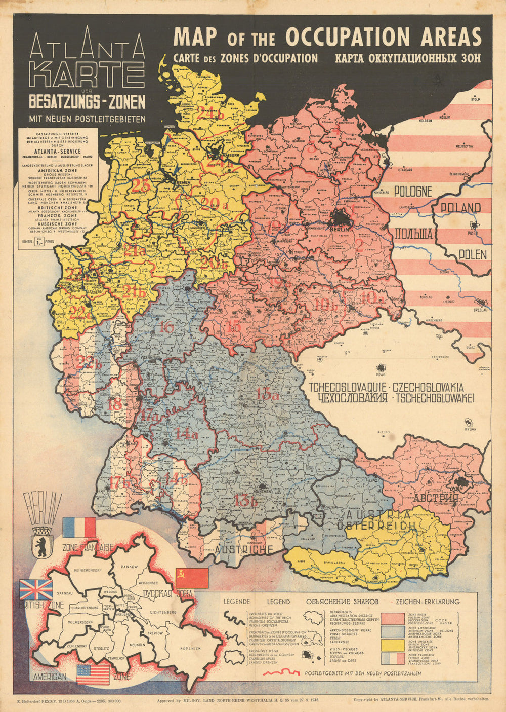
'Atlanta Karte der Besatzungs-Zonen mit neuen Postleitgebieten - Map of the Occupation Areas - Carte des Zones d'Occupation'
A map of Germany and Austria shortly after the end of the Second World War, published with the approval of the British Military Government of North Rhine Westphalia. The map shows the partition of defeated Germany and Austria into French, British, American and Russian occupation zones, as agreed at the Potsdam Conference in August 1945 and earlier in principle at Yalta, with an inset showing the division of Berlin. The Russian zones are marked in pink, the American blue, the British yellow, and the French red, white & blue stripes. To the east Poland is shown with its new borders shifted to the west and colored with pink stripes, presumably a reference to Russian influence or occupation. The map has a cover price of one Reichsmark, the currency of Germany between 1924 and 1948, when it was replaced by the Deutschmark. The map includes much detail including the new postal districts and codes introduced by the Allies after the war. The draughtsman has been identified as Johannes Sünnecke. The state of North Rhine Westphalia had itself been created on 23 August 1946, only a month prior to the publication of the map, by the British military administration's "Operation Marriage" which had merged the province of Westphalia and the northern parts of the Rhine Province, both being political divisions of the former state of Prussia within the German Reich.
Browse available examples:
Size 54 x 39 cm | 21.5 x 15.0 inches
Date Published: 17072
Type: Poster map of post World War Two showing the occupation of Germany and Austria by the victorious Allied powers
Author: Atlanta Service
Publication: Map of the Occupation Areas
Condition: Good |
Delivery & Returns
Packing
Items smaller than A4 size are usually packed in a stiffened, board-backed envelope. Larger items are rolled and packed in postal tubes. Large items which are too stiff to be rolled in wide-diameter tubes are mailed in all-board envelopes. In the unlikely event of damage in transit, please send the affected item or items back to us and we will provide a replacement or refund.
Delivery
Economy, tracked and express shipping options are available to all destinations worldwide. Over half our orders are sent to customers outside the United Kingdom and we have supplied over 30,000 buyers in over 70 different countries. We ship orders virtually every business day to customers in North America and Europe. The cost of delivery depends on the size of the largest item in your order, where you are located, and the delivery method that you choose at checkout. For orders received before 2pm, we can arrange delivery next day in the UK, within 2 business days to continental Europe and North America, and within 4 days to most other countries worldwide (excludes PO Box or APO/FPO (Military) addresses).
Returns
We accept returns for any reason if sent back to us within 14 days of receipt of your order. If any of your items are not as described, we will provide a full refund including reasonable return postage costs upon safe return to us. If you have changed your mind, you are responsible for the cost of returning the item to us. We describe the size, age and condition of all our products as fully and accurately as possible. Most of the items which we sell are in very good condition. However, the condition of antique and vintage prints and maps can vary. All of our product listings including a statement which classifies the condition as being either “Good”, “Fair”, or (rarely) “Poor” and which describes any material flaws, blemishes, imperfections or other significant features such as folds. Please read the description carefully before purchase.
Can we help? For more details or any questions.