Chart of the Friendly Islands. Cook's discovery of Tonga. HOGG 1784 old map
SKU
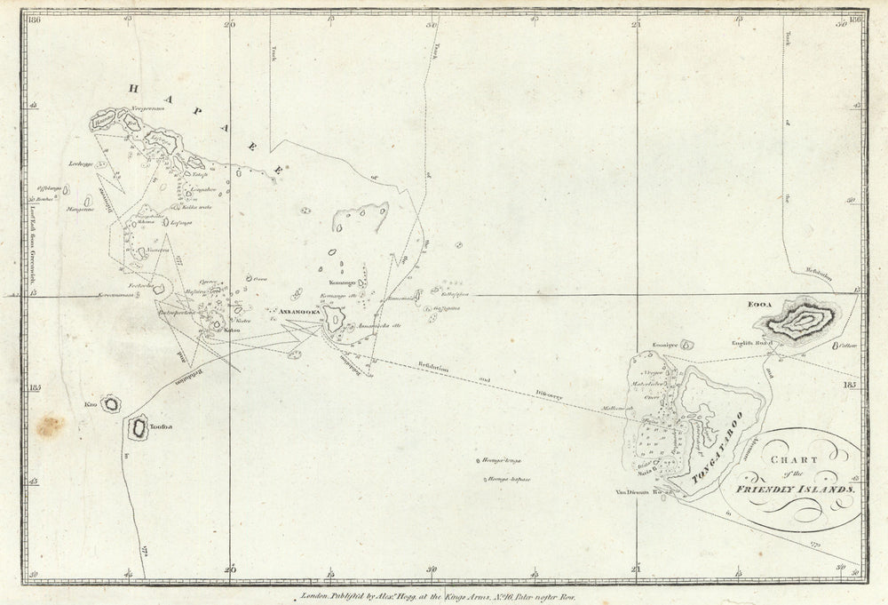
'Chart of the Friendly Islands'
This map illustrates Captain Cook's route around the Tongan Islands, which he visited during his second voyage of exploration in the Pacific Ocean. These islands were discovered by Cook in 1773, and the map marks the tracks of his voyages during 1773, 1774, and 1777. The archipelago is historically known as the Friendly Islands due to the warm reception Cook initially received from the islanders. His arrival coincided with the annual ceremony of the First Fruits, where offerings were made to the Tu'i Tonga, the paramount chief of Tonga. Cook and his crew were invited to participate in the associated festivities. However, as noted by William Mariner, an English writer who lived in Tonga, the Tongan chiefs had actually intended to kill Cook and his crew during the gathering but were unable to agree on a specific plan, thus sparing his life. The map is oriented to the east, with the Tongatapu group of islands positioned at the bottom and the Ha'apai group shown at the top, providing an overview of the region Cook explored.
Size 24 x 35 cm | 9.5 x 14.0 inches
Date Published: 1784
Type: Antique copperplate map
Author: Hogg, Alexander
Publication: A New, Authentic & Complete Collection Voyages Round the World
Condition: Good |
Delivery & Returns
Packing
Items smaller than A4 size are usually packed in a stiffened, board-backed envelope. Larger items are rolled and packed in postal tubes. Large items which are too stiff to be rolled in wide-diameter tubes are mailed in all-board envelopes. In the unlikely event of damage in transit, please send the affected item or items back to us and we will provide a replacement or refund.
Delivery
Economy, tracked and express shipping options are available to all destinations worldwide. Over half our orders are sent to customers outside the United Kingdom and we have supplied over 30,000 buyers in over 70 different countries. We ship orders virtually every business day to customers in North America and Europe. The cost of delivery depends on the size of the largest item in your order, where you are located, and the delivery method that you choose at checkout. For orders received before 2pm, we can arrange delivery next day in the UK, within 2 business days to continental Europe and North America, and within 4 days to most other countries worldwide (excludes PO Box or APO/FPO (Military) addresses).
Returns
We accept returns for any reason if sent back to us within 14 days of receipt of your order. If any of your items are not as described, we will provide a full refund including reasonable return postage costs upon safe return to us. If you have changed your mind, you are responsible for the cost of returning the item to us. We describe the size, age and condition of all our products as fully and accurately as possible. Most of the items which we sell are in very good condition. However, the condition of antique and vintage prints and maps can vary. All of our product listings including a statement which classifies the condition as being either “Good”, “Fair”, or (rarely) “Poor” and which describes any material flaws, blemishes, imperfections or other significant features such as folds. Please read the description carefully before purchase.
Can we help? For more details or any questions.