'L'Amerique'. North America & newly independent South America. BUCHON 1825 map
SKU
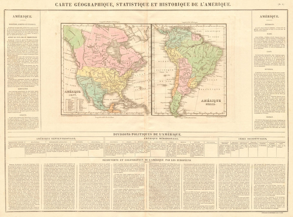
'Carte géographique, statistique et historique de l'Amerique'
The North American map shows Mexico with its borders prior to the Mexican-American war, with its territory including Texas and much of what is now the south- western part of the United States. Alaska is shown as Russian America, as was the case until the Alaska purchase of 1867. The border between the United States and British North America (now Canada) follows the Columbia River to the Pacific - later amended by the Oregon Treaty. The South American map shows the continent with a number of newly formed states which had recently gained independence from Spain and Portugal. The map shows Gran Colombia, the modern name for the short-lived state that encompassed much of northern South America and Panama from 1819 to 1831; it included the territories of present-day Colombia, Venezuela, Ecuador, Panama, northern Peru, western Guyana and northwest Brazil. The United Provinces of Rio de la Plata (Provincias Unidas del Río de la Plata) are delineated to include much of present day Argentina (excluding Entre Rios - marked as an independent state, and Patagonia), Bolivia, and part of Brazil. Uruguay - whch had declared independence in the year of publication of this map - is named as 'Banda Oriental'.
Size 49 x 66 cm | 19.5 x 26.0 inches
Date Published: 1825
Type: Very decorative early 19th century antique hand-coloured engraved map. Text in French.
Author: Buchon, Jean Alexandre
Publication: Atlas des Deux Amériques
Condition: Good |
Delivery & Returns
Packing
Items smaller than A4 size are usually packed in a stiffened, board-backed envelope. Larger items are rolled and packed in postal tubes. Large items which are too stiff to be rolled in wide-diameter tubes are mailed in all-board envelopes. In the unlikely event of damage in transit, please send the affected item or items back to us and we will provide a replacement or refund.
Delivery
Economy, tracked and express shipping options are available to all destinations worldwide. Over half our orders are sent to customers outside the United Kingdom and we have supplied over 30,000 buyers in over 70 different countries. We ship orders virtually every business day to customers in North America and Europe. The cost of delivery depends on the size of the largest item in your order, where you are located, and the delivery method that you choose at checkout. For orders received before 2pm, we can arrange delivery next day in the UK, within 2 business days to continental Europe and North America, and within 4 days to most other countries worldwide (excludes PO Box or APO/FPO (Military) addresses).
Returns
We accept returns for any reason if sent back to us within 14 days of receipt of your order. If any of your items are not as described, we will provide a full refund including reasonable return postage costs upon safe return to us. If you have changed your mind, you are responsible for the cost of returning the item to us. We describe the size, age and condition of all our products as fully and accurately as possible. Most of the items which we sell are in very good condition. However, the condition of antique and vintage prints and maps can vary. All of our product listings including a statement which classifies the condition as being either “Good”, “Fair”, or (rarely) “Poor” and which describes any material flaws, blemishes, imperfections or other significant features such as folds. Please read the description carefully before purchase.
Can we help? For more details or any questions.