London & North Eastern Railway. London Goods Cartage Boundary c1925 old map
£180
SKU
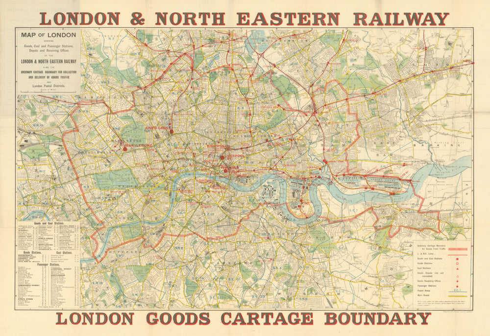
London & North Eastern Railway – London Goods Cartage Boundary. Map of London shewing Goods, Coal and Passenger Stations, Depots and Receiving Offices of the London & North Eastern Railway. [Goods Cartage Boundary for Collection and Delivery of Traffic]
This is a London goods cartage boundary map, issued to show the zone within which the London North Eastern Railway Company would collect and deliver freight locally, presumably at a standard tariff or without an additional cartage charge applied. The map outlines a defined “Ordinary Cartage Boundary” surrounding London, inside which customers could rely on the railway to handle the short-haul transport of goods between stations, depots, and receiving offices. Freight infrastructure is prominently marked: goods and coal depots, railway goods stations, receiving offices and cartage depots, providing a detailed snapshot of how industrial London managed distribution during the early-20th century, when railways coordinated both long-distance haulage and local delivery. As such, this map represents an important piece of commercial transport history, capturing the logistics network that kept London’s industries operating before nationalisation of the major mainline companies in 1948.
Size 62 x 90 cm | 24.5 x 35.5 inches
Date Published: Circa 1925. Undated. Dating clues are inconsistent
Type: Antique colour transport map and city plan, bound into original wrapper
Author: Stanford, Edward
Publication: London & North Eastern Railway – London Goods Cartage Boundary
Condition: Good |
Delivery & Returns
Packing
Items smaller than A4 size are usually packed in a stiffened, board-backed envelope. Larger items are rolled and packed in postal tubes. Large items which are too stiff to be rolled in wide-diameter tubes are mailed in all-board envelopes. In the unlikely event of damage in transit, please send the affected item or items back to us and we will provide a replacement or refund.
Delivery
Economy, tracked and express shipping options are available to all destinations worldwide. Over half our orders are sent to customers outside the United Kingdom and we have supplied over 30,000 buyers in over 70 different countries. We ship orders virtually every business day to customers in North America and Europe. The cost of delivery depends on the size of the largest item in your order, where you are located, and the delivery method that you choose at checkout. For orders received before 2pm, we can arrange delivery next day in the UK, within 2 business days to continental Europe and North America, and within 4 days to most other countries worldwide (excludes PO Box or APO/FPO (Military) addresses).
Returns
We accept returns for any reason if sent back to us within 14 days of receipt of your order. If any of your items are not as described, we will provide a full refund including reasonable return postage costs upon safe return to us. If you have changed your mind, you are responsible for the cost of returning the item to us. We describe the size, age and condition of all our products as fully and accurately as possible. Most of the items which we sell are in very good condition. However, the condition of antique and vintage prints and maps can vary. All of our product listings including a statement which classifies the condition as being either “Good”, “Fair”, or (rarely) “Poor” and which describes any material flaws, blemishes, imperfections or other significant features such as folds. Please read the description carefully before purchase.
Can we help? For more details or any questions.