London road/rail plans.EMBANKMENT CHARING CROSS QUEEN VICTORIA STREET 1855 map
£65
SKU
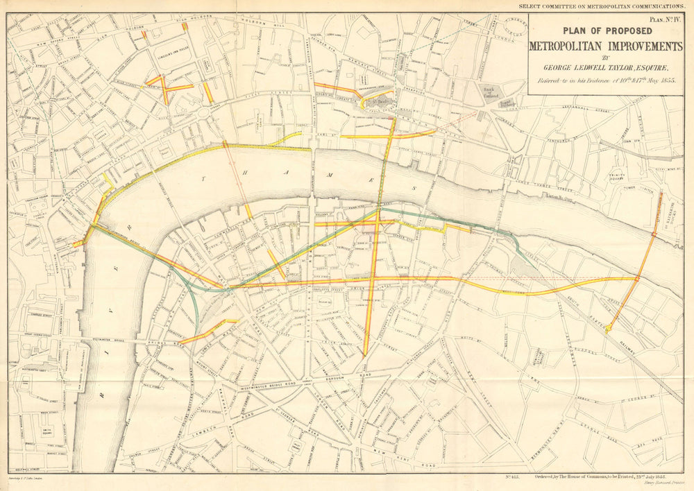
'Plan of Proposed Metropolitan Improvements referred to by George Ledwell Taylor Esq in his evidence of 10th and 17th May 1855'
The map indicates a number of proposed road and rail developments. These noteably include 1) the construction of a rail line across Hungerford Bridge, connecting to the lines running south from Waterloo station and east to the lines running out of London from London Bridge station (Charing Cross station was opened in 1864 with rail lines connecting to existing lines running out of London Bridge station via a different route); 2) A Thames Embankment (on which construction started in 1862); 3) A new bridge over the Thames between Blackfriars and Waterloo (never built); 4) A new road bridge over the Thames east of the Tower (construction started in 1886); 5) A new road and rail bridge over the Thames running south from St Paul's Cathedral (The Millenium foot bridge was completed nearby in 2000); 6) Major new roads connecting the above running east-west and north-south through Southwark (never built)
Size 37 x 52 cm | 14.5 x 20.5 inches
Date Published: 23 July 1855
Type: Antique map with original colour, prepared for consideration by the British Parliamentary Select Committee on Metropolitan Communication
Author: Taylor, George Ledwell
Publication: Metropolitan Communications Hansard Report
Condition: Good |
Delivery & Returns
Packing
Items smaller than A4 size are usually packed in a stiffened, board-backed envelope. Larger items are rolled and packed in postal tubes. Large items which are too stiff to be rolled in wide-diameter tubes are mailed in all-board envelopes. In the unlikely event of damage in transit, please send the affected item or items back to us and we will provide a replacement or refund.
Delivery
Economy, tracked and express shipping options are available to all destinations worldwide. Over half our orders are sent to customers outside the United Kingdom and we have supplied over 30,000 buyers in over 70 different countries. We ship orders virtually every business day to customers in North America and Europe. The cost of delivery depends on the size of the largest item in your order, where you are located, and the delivery method that you choose at checkout. For orders received before 2pm, we can arrange delivery next day in the UK, within 2 business days to continental Europe and North America, and within 4 days to most other countries worldwide (excludes PO Box or APO/FPO (Military) addresses).
Returns
We accept returns for any reason if sent back to us within 14 days of receipt of your order. If any of your items are not as described, we will provide a full refund including reasonable return postage costs upon safe return to us. If you have changed your mind, you are responsible for the cost of returning the item to us. We describe the size, age and condition of all our products as fully and accurately as possible. Most of the items which we sell are in very good condition. However, the condition of antique and vintage prints and maps can vary. All of our product listings including a statement which classifies the condition as being either “Good”, “Fair”, or (rarely) “Poor” and which describes any material flaws, blemishes, imperfections or other significant features such as folds. Please read the description carefully before purchase.
Can we help? For more details or any questions.