Map of the islands of St Lucia & Martinique… by John Lodge 1781 old
SKU
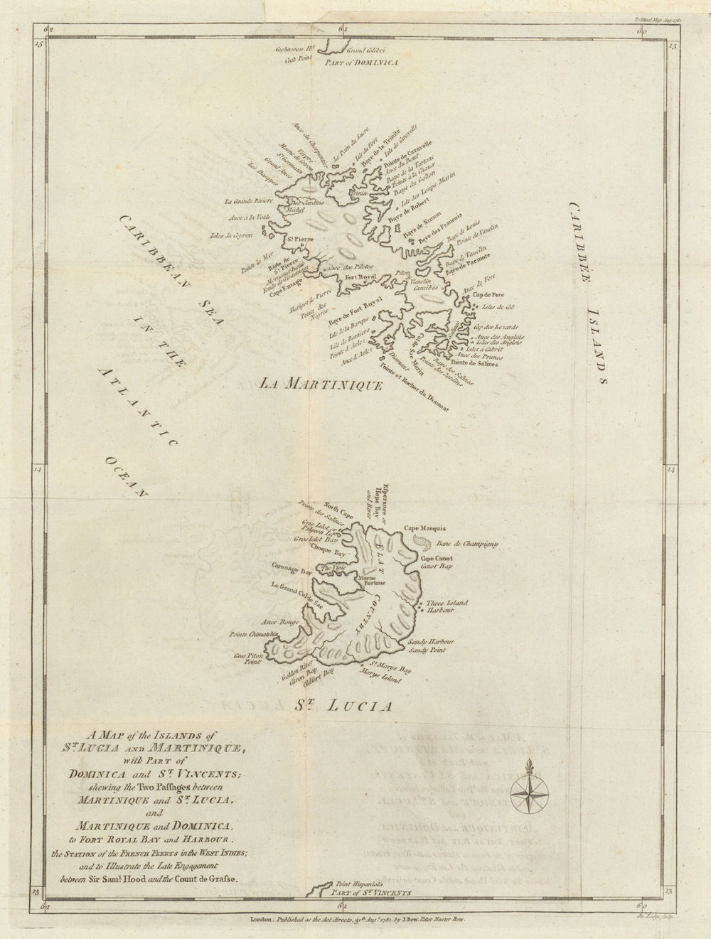
'Map of the islands of St Lucia & Martinique with part of Dominica and St. Vincents; shewing the two passages between Martinique and St. Lucia, and Martinique and Dominica, to Fort Royal and harbour, the Station of the French Fleets in the West Indies; and to illustrate the Late Engagement between Sir. Saml. Hood and the Count de Grasse'
A rare map of St. Lucia and Martinique, accompanied by a detailed description of both islands. These islands were topical at the time of publication due to the recent Battle of Fort Royal, which had taken place in April 1781. This naval battle was fought off Fort Royal, Martinique, in the West Indies during the Anglo-French War - related to the American Revolutionary War - between fleets of the British Royal Navy and the French Navy. After an engagement lasting four hours, the British squadron under Admiral Samuel Hood withdrew and retreated. Admiral de Grasse pursued briefly before ensuring the safe arrival of the French convoys at port.
Size 40 x 30 cm | 15.5 x 12.0 inches
Date Published: August 1781
Type: Antique copperplate map. The accompanying text article, originally published with the map, will be included
Author: Lodge, John
Publication: Political Magazine
Condition: Good |
Delivery & Returns
Packing
Items smaller than A4 size are usually packed in a stiffened, board-backed envelope. Larger items are rolled and packed in postal tubes. Large items which are too stiff to be rolled in wide-diameter tubes are mailed in all-board envelopes. In the unlikely event of damage in transit, please send the affected item or items back to us and we will provide a replacement or refund.
Delivery
Economy, tracked and express shipping options are available to all destinations worldwide. Over half our orders are sent to customers outside the United Kingdom and we have supplied over 30,000 buyers in over 70 different countries. We ship orders virtually every business day to customers in North America and Europe. The cost of delivery depends on the size of the largest item in your order, where you are located, and the delivery method that you choose at checkout. For orders received before 2pm, we can arrange delivery next day in the UK, within 2 business days to continental Europe and North America, and within 4 days to most other countries worldwide (excludes PO Box or APO/FPO (Military) addresses).
Returns
We accept returns for any reason if sent back to us within 14 days of receipt of your order. If any of your items are not as described, we will provide a full refund including reasonable return postage costs upon safe return to us. If you have changed your mind, you are responsible for the cost of returning the item to us. We describe the size, age and condition of all our products as fully and accurately as possible. Most of the items which we sell are in very good condition. However, the condition of antique and vintage prints and maps can vary. All of our product listings including a statement which classifies the condition as being either “Good”, “Fair”, or (rarely) “Poor” and which describes any material flaws, blemishes, imperfections or other significant features such as folds. Please read the description carefully before purchase.
Can we help? For more details or any questions.