
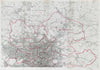

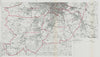

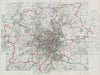

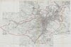

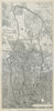

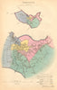

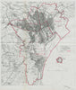

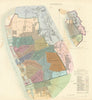

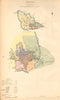


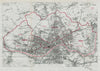

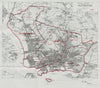

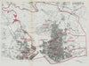

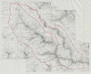

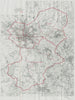

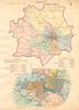


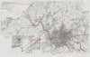

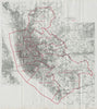

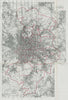


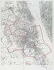

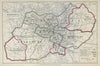


Four pivotal series of British boundary maps produced for major electoral and administrative reforms between 1837 and 1918. The earliest, compiled in 1837 by Lieutenant Robert Kearsley Dawson, was commissioned by the General Register Office in the wake of the Reform Act of 1832. These maps proposed rationalised registration districts and administrative divisions to support census-taking and civil governance, laying the groundwork for future administrative geography. The 1867–68 maps, prepared under Captain Henry James of the Ordnance Survey, accompanied the Second Reform Act and redrew constituency boundaries to reflect industrial growth and expanded suffrage. In 1888, Robert Owen Jones produced a new set of boundary maps following the Redistribution of Seats Act 1885, which introduced single-member constituencies across much of the UK. The final set in this collection, compiled in 1917 by Colonel Charles Frederick Arden-Close and George Frederick Ashwood Whitlock, was created for the Boundary Commission in advance of the Representation of the People Act 1918. These maps reflect the first truly modern attempt at national electoral redistricting in the age of mass democracy. All four series draw on Ordnance Survey mapping and illustrate the evolving precision and complexity of British electoral geography across nearly a century of reform.
EU orders up to €150 are sent VAT- and duty-paid — no additional taxes on arrival
Authenticity Guaranteed - We only sell original antique & vintage items
Can we help? Call us on +44-208-960-3476 • FAQs
All our products are exempt from US tariffs — no additional duties or taxes payable on arrival.
- Shop by Country
- Shop by Cartographer
- Shop Maps by Type
- Shop Prints by Subject