
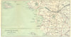


The Breton coast and the Loire country meet in these maps from Brittany & Touraine, C. B. Black's travel guide published by Adam and Charles Black in 1914. Town plans of Saint-Servan, Angers, Saumur and Orléans sit beside regional excursion sheets, with mapping around the Loire estuary and Nantes joining inland travel to the Atlantic, and the Arguenon and its coastal villages offering smaller journeys in northern Brittany. Belle-Île adds an offshore destination. Made before the war, the maps divide a varied part of western France into the routes, towns and excursions of rail-era travel.
EU orders up to €150 are sent VAT- and duty-paid — no additional taxes on arrival
Authenticity Guaranteed - We only sell original antique & vintage items
Can we help? Call us on +44-208-960-3476 • FAQs
All our products are exempt from US tariffs — no additional duties or taxes payable on arrival.


- Shop by Country
- Shop by Cartographer
- Shop Maps by Type
- Shop Prints by Subject