


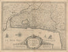


Vineyards and named estates run through these maps of the Gironde, giving them a richness far beyond a simple departmental outline. Féret maps of the department dated 1921 and 1924 appear with detailed sheets of Sauternes and Barsac from 1946, and a wider regional wine map links Bordeaux with neighbouring river valleys and producing areas. The maps move from the regional framework down to the vineyards and appellations within it, in the vocabulary of their own period, while earlier geographical material and prints place the wine country among its towns, waterways and administrative geography.
EU orders up to €150 are sent VAT- and duty-paid — no additional taxes on arrival
Authenticity Guaranteed - We only sell original antique & vintage items
Can we help? Call us on +44-208-960-3476 • FAQs
All our products are exempt from US tariffs — no additional duties or taxes payable on arrival.


- Shop by Country
- Shop by Cartographer
- Shop Maps by Type
- Shop Prints by Subject