Hide out of stock items

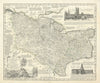
A map from "The Royal English Atlas", by Emanuel Bowen, Geographer to His late Majesty, Thomas Kitchin, Geographer and others. London: Printed for Thomas Kitchin on Holborn-Hill; Robert Sayer, in Fleet-Street; Carington Bowles in St. Pauls Church-Yard, Henry Overton, without Newgate. Henry Parker & John Bowles, in Cornhill; and John Ryall, in Fleet Street (1762)