


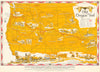


Clarence King's 1876 survey of the fortieth parallel, the Oregon Trail and Pacific resources mapped for Fortune give these maps of the American West a remarkable span from scientific exploration to mid-twentieth-century graphic design. King's atlas supplies an index to the western Cordilleras, Richard Edes Harrison's 1945 Fortune map shows the Pacific watershed in perspective, and another Fortune sheet associated with Walt Disney Productions depicts the resources of the Pacific coast. Irvin Shope's 1948 pictorial map follows the Oregon Trail. Earlier atlas maps by Ettling preserve Utah and New Mexico territories and boundaries from before Nevada's expansion, a California map places Las Vegas within the earlier Arizona boundary, and other sheets record railways across California, Nevada and Oregon.
EU orders up to €150 are sent VAT- and duty-paid — no additional taxes on arrival
Authenticity Guaranteed - We only sell original antique & vintage items
Can we help? Call us on +44-208-960-3476 • FAQs
All our products are exempt from US tariffs — no additional duties or taxes payable on arrival.


- Shop by Country
- Shop by Cartographer
- Shop Maps by Type
- Shop Prints by Subject