
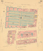


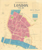

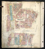

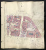

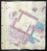

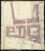

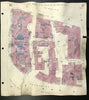

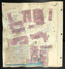

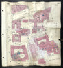

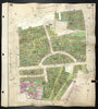

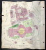

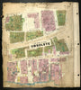


Large detailed fire insurance plans of the West End & Legal London by Charles Goad & Co. The maps were overlaid to show changes in building use or condition, including World War 2 bomb damage. These very scarce maps were prepared by the civil engineering firm Charles Goad and Co for insurance and related purposes. The maps, prepared on a scale of 40 feet to 1 inch, show individual properties, businesses and shops. Larger businesses are individually named, and the use to which each building was described. The circulation of these plans amongst insurance companies, fire brigades and other interested parties was strictly controlled by Goad on a rental basis, and apparently never sold. The maps were revised and updated through to 1948 to reflect the influence of the Second World War between 1939 and 1945 (Buildings damaged or destroyed by bombs are marked green). These plans provide a historical insight into the buildings of central London in the immediate post-war period, prior to the substantial rebuilding and redevelopment seen in subsequent decades.
EU orders up to €150 are sent VAT- and duty-paid — no additional taxes on arrival
Authenticity Guaranteed - We only sell original antique & vintage items
Can we help? Call us on +44-208-960-3476 • FAQs
All our products are exempt from US tariffs — no additional duties or taxes payable on arrival.
- Shop by Country
- Shop by Cartographer
- Shop Maps by Type
- Shop Prints by Subject