


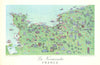


Rémy Hétreau (1913-2001) was French painter, graphic artist, printmaker, illustrator and designer. He was commissioned in the 1950s by the Comité National de Propagande en Faveur du Vin, a French government agency tasked with promoting the nation's wines and tourism to the wine growing regions, to create a series of illustrated maps entitled "Les Vignobles de France". There were supposedly eleven of these: Région Est, Normandie, Champagne, Bordeaux, Rhône, Bourgogne, Provence, Alsace, Loire, Roussillon & what was then the French colony of Algeria. However, Provence & Roussillon were combined into a single map, and we have never seen examples of the maps for Région Est or Normandie - neither of which regions are particularly noted for their wine. His highly decorative, exuberant maps display a joyful mid-century aesthetic; they have become much sought after. Art critic René Barjavel said of him "In the world around him, it is always springtime. He has a blossoming tree in his heart"; a comment evident in these wonderful maps. He also created designs for Haviland Limoges china and painted murals (notably at the Maison de l'Amerique Latine in Paris and the Ecole Nationale des Douanes).
EU orders up to €150 are sent VAT- and duty-paid — no additional taxes on arrival
Authenticity Guaranteed - We only sell original antique & vintage items
Can we help? Call us on +44-208-960-3476 • FAQs
All our products are exempt from US tariffs — no additional duties or taxes payable on arrival.
- Shop by Country
- Shop by Cartographer
- Shop Maps by Type
- Shop Prints by Subject