Map or Print
Choose
Map
Print
Geographic category
Choose
#N/A
Aberdeenshire
Abingdon
Abruzzo
Adelaide
Aegean
Afghanistan
Africa
African Islands
Ain
Aisne
Alabama
Alaska
Albania
Alberta
Algeria
Allier
Alpes-de-Haute-Provence
Alpes-Maritimes
Alps
Alsace
Americans
Americas
Amsterdam
Ancient World
Andalusia
Andaman Nicobar Islands
Andean States
Andhra Pradesh
Andorra
Anglesey
Angola
Antarctic
Antarctica
Antrim
Antwerp
Aosta
Appalachia
Apulia
Aquitaine
Arabia
Arctic
Arctic Expeditions
Arctic Ocean
Ardèche
Ardennes
Argentina
Argentina Chile
Argyll and Bute
Ariege
Ariège
Arizona
Arkansas
Armagh
Armenia
Armillary
Ascension Island
Asia
Asians
Assam
Assyria
Athens
Atlantic
Atlantic Islands
Atlantic Ocean
Aube
Aude
Australasia
Australia
Austria
Austria Hungary
Austria/Germany
Austria/Italy
Austria-Hungary
Auvergne
Aveyron
Ayrshire
Azerbaijan
Azores
Baden-Württemberg
Bahamas
Bahrain
Balearic Islands
Balkans
Baltic
Baltic Sea
Baltic States
Baltics
Baltimore
Bamberg
Bangladesh
Bangladesh/India
Barbados
Basilicata
Bas-Rhin
Bath
Bavaria
Bedfordshire
Beijing
Belarus
Belfort
Belgium
Belize
Benelux
Benin
Berkshire
Berlin
Bermuda
Bhutan
Birmingham
Bismarck Archipelago
Black Sea
Blue Mountains
Bolivia
Bonin Islands
Bordeaux
Borneo
Bosnia
Bosnia and Herzegovina
Bosnia Herzegovina
Boston
Botswana
Bouches-du-Rhône
Bourgogne
Bourgogne-Franche-Comté
Brandenburg
Brazil
Brecknockshire
Bremen
Bretagne
Bridgend
Brisbane
Bristol
Britanny
British Army
British Columbia
British Empire
British History
British India
British Isles
Brittany
Brunei
Brunei Darussalam
Buckinghamshire
Bucks
Bulgaria
Burgundy
Burkina Faso
Burma
Burundi
Cairo
Caithness
Calabria
California
Calvados
Cambodia
Cambridge
Cambridgeshire
Cameroon
Campania
Canada
Canary Islands
Cannes
Cantabria
Cantal
Cape Verde
Cardiganshire
Caribbean
Carlow
Carmarthenshire
Carnarvonshire
Carolinas
Caroline Islands
Caspian Sea
Caucasus
Caucasus & Iraq
Cavan
Cayman Islands
Central Africa
Central African Republic
Central America
Central Asia
Central Europe
Centre-Val de Loire
Ceylon
Chad
Chagos Archipelago
Champagne
Channel Islands
Channel Isles
Charente
Charente-Maritime
Chatham
Chelsea
Cheltenham
Cher
Chesapeake Bay
Cheshire
Chicago
Chile
China
Clapham
Clare
Cobham
Cocos Islands
Cognac
Colombia
Colombia Venezuela
Colorado
Comoros
Congo
Connacht
Connecticut
Constantinpole
Cook Islands
Cork
Cornwall
Corrèze
Corse-du-Sud
Corsica
Costa Rica
Côte d'Ivoire
Côte-d'Or
Côtes-d'Armor
Cotswolds
Coventry
Crete
Creuse
Cricklewood
Crimea
Crimean War
Croatia
Cuba
Cumbria
Curaçao
Cyprus
Czech
Czech Republic
Czechia
Czechia Poland
Czechoslovakia
Dakota
Dauphine
Delaware
Denbighshire
Denmark
Derbyshire
Deux-Sèvres
Devon
Dieppe
District of Columbia
Djerba
Djibouti
Dominica
Dominican Republic
Doncaster
Donegal
Dordogne
Dorset
Doubs
Down
Drôme
Dublin
Dumfriesshire
Dunedin
Durham
Dutch East Indies
East Africa
East Anglia
East Asia
East Indies
East Midlands
Eastern Europe
Eastern France
Eastern Hemisphere
Eastern Roman Empire
Ecuador
Edgware
Edinburgh
Edinburghshire
Egypt
Egypt & Sudan
Egypt Syria
El Salvador
Emilia-Romagna
England
England & Wales
English Channel
English cities
Epsom
Equatorial Guinea
Eritrea
Essex
Essonne
Estonia
Ethiopia
Eton
Eurasia
Eure
Eure-et-Loir
Europe
European Cities
European Colonies
Falkland Islands
Feltham
Fermanagh
Fiji
Finistère
Finland
Flanders
Flintshire
Florence
Florida
France
Franche-Comté
Franco-Prussian War
French Alps
French Colonies
French Equatorial Africa
French Guiana
French Polynesia
French ports
French Sudan
French West Africa
French West Indies
Friuli-Venezia Giulia
Gabon
Galapagos Islands
Galicia
Galway
Gambia
Gard
Gascony
Georgia
Georgia (country)
Georgia (US state)
Georgia, US
Germany
Germany Poland
Germany/Austria
Gers
Ghana
Ghent
Gibraltar
Gilbert Islands
Gironde
Glamorganshire
Glasgow
Gloucester
Gloucestershire
Grand Est
Great Britain
Greece
Greece/Turkey
Greenland
Guatemala
Guianas
Guinea
Guinea-Bissau
Gujarat
Gulf of Mexico
Guyana
Gwynedd
Hackney
Haddingtonshire
Haiti
Hamburg
Hampshire
Hampstead
Hampton Court
Harrow
Haut-Corse
Haute-Corse
Haute-Garonne
Haute-Loire
Haute-Marne
Haute-Normandie
Hautes-Alpes
Haute-Saône
Haute-Savoie
Hautes-Pyrénées
Haute-Vienne
Haut-Rhin
Hauts-de-France
Hauts-de-Seine
Hawaii
Hebrides
Henry VIII
Hérault
Hereford
Herefordshire
Hertfordshire
Herzegovina
Hesse
Hessen
Himalayas
Hispaniola
Holland
Home Counties
Honduras
Hong Kong
Horn of Africa
Hungary
Hunter Valley
Huntingdonshire
Hunts
Hyde Park
Iberia
Iceland
Idaho
Île-de-France
Ille-et-Vilaine
Illinois
India
India/Bangladesh
India/Pakistan
Indian Ocean
Indian Ocean Islands
Indiana
Indochina
Indonesia
Indre
Indre-et-Loire
Inverness-shire
Iowa
Iran
Iraq
Ireland
Irish Sea
Isère
Isle of Man
Isle of Wight
Isleworth
Islington
Israel
Istanbul
Italy
Italy/Austria
Italy/Switzerland
Ivory Coast
Jakarta
Jamaica
Japan
Japan Korea
Java
Jenolan Caves
Jerusalem
Jordan
Jura
Kansas
Kashmir
Kazakhstan
Kent
Kent Sussex
Kentucky
Kenya
Kerala
Kerry
Kildare
Kilkenny
Kirkcudbrightshire
Korea
Kurdistan
Kuwait
Kyrgyzstan
La Reunion
Lancashire
Lancaster
Landes
Languedoc
Laois
Laos
Latvia
Latvia Lithuania Estonia
Lazio
Lebanon
Leeds
Leicester
Leicestershire
Leichtenstein
Leinster
Leitrim
Lesotho
Levant
Liberia
Libya
Liechtenstein
Liguria
Limerick
Lincoln
Lincolnshire
Lisbon
Lithuania
Liverpool
Loire
Loire valley
Loire-Atlantique
Loiret
Loir-et-Cher
Lombardy
London
London Concert Halls
London Sports Grounds
London Theatres
Londonderry
Longbridge
Longford
Lorraine
Lot
Lot-et-Garonne
Lothian
Louisiana
Louth
Lower Saxony
Lozère
Lubeck
Luxembourg
Lyon
Macao
Macau
Macedonia
Madagascar
Madeira
Madrid
Maghreb
Maharashtra
Maine
Maine-et-Loire
Malawi
Malaysia
Maldives
Mali
Malta
Malvern Link
Manche
Manchester
Manitoba
Marche
Marianas
Marne
Marshall Islands
Maryland
Massachusetts
Massif Central
Mauritania
Mauritius
Mayenne
Mayo
Meath
Mecklenburg-Vorpommern
Mediterranean
Melanesia
Melbourne
Merionethshire
Merseyside
Mesopotamia
Meurthe
Meurthe-et-Moselle
Meuse
Mexico
Mexico City
Mexico/Panama
Michigan
Micronesia
Mid Atlantic States
Middle East
Middlesex
Midwestern USA
Minnesota
Mississippi
Mississippi Valley
Missouri
Moldova
Monaco
Monaghan
Mongolia
Monmouth
Monmouthshire
Montana
Montenegro
Montgomeryshire
Montparnasse
Morbihan
Morocco
Moselle
Mozambique
Myanmar
Namibia
Nantes
Naples
Nashville
NATO
Nauru
Nebraska
Nepal
Netherlands
Nevada
New Brunswick
New Caledonia
New England
New Guinea
New Hampshire
New Jersey
New Mexico
New Orleans
New South Wales
New York
New York City
New Zealand
Newcastle-upon-Tyne
Newfoundland and Labrador
Newmarket
Nicaragua
Niedersachsen
Nièvre
Niger
Nigeria
Nord
Norfolk
Norfolk Island
Normandy
North Africa
North America
North Asia
North Atlantic
North Carolina
North Dakota
North East Africa
North East Asia
North East England
North Korea
North Rhine-Westphalia
North Sea
North Wales
North West England
North West Europe
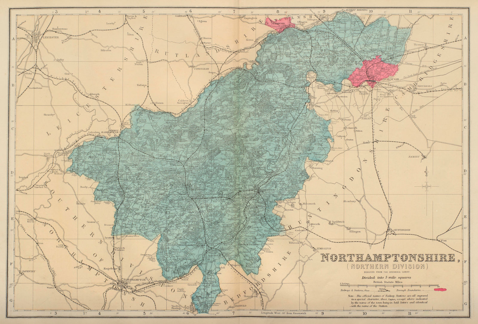
Northamptonshire
Northern England
Northern Europe
Northern France
Northern Ireland
Northern Territory
Northrhine-Westfalia
Northumberland
Norway
Norwich
Nottingham
Nottinghamshire
Nova Scotia
Nubia
Occitanie
Oceania
Offaly
Ohio
Oise
Oklahoma
Oman
Ontario
Oregon
Orkney
Orne
Ostend
Ottoman Empire
Oxford
Oxfordshire
Pacific
Pacific Islands
Pacific Northwest
Pacific Ocean
Pakistan
Pakistan/India
Palestine
Panama
Papau New Guinea
Papua New Guinea
Paraguay
Paris
Pas-de-Calais
Pays de la Loire
Pembrokeshire
Pennsylvania
Persia
Persia Iran
Peru
Peru Bolivia
Philadelphia
Philippines
Picardie
Piedmont
Poland
Poland-Lithuania
Polar regions
Polynesia
Pompeii
Portsmouth
Portugal
Powys
Preston
Provence
Provence-Alpes-Côte-d'Azur
Prussia
Puerto Rico
Puy-de-Dôme
Pyrenees
Pyrénées
Pyrénées-Atlantiques
Pyrénées-Orientales
Qatar
Quebec
Queensland
Radnorshire
Réunion
Reunion Island
Rhine valley
Rhineland-Palatinate
Rhode Island
Rhône
Rhône Valley
Rhône-Alpes
Roman Empire
Romania
Rome
Roscommon
Ross-shire
Rouen
Rugby School
Russia
Russia in Europe
Russia/Ukraine
Russian Caucasus
Rutland
Rwanda
Saarland
Samoa
San Francisco
San Marino
Sao Tome
Saône-et-Loire
Sardinia
Sarmatia
Sarthe
Saudi Arabia
Savoie
Saxony
Saxony-Anhalt
Scandinavia
Schleswig-Holstein
Scilly Isles
Scotland
Scotsmen
Scottish Cities
Scottish Highlands
Seine
Seine-et-Marne
Seine-et-Oise
Seine-Maritime
Seine-Saint-Denis
Senegal
Senegal/Mauritania
Serbia
Severn Valley
Seychelles
Shropshire
Siberia
Sicily
Sierra Leone
Sierra Nevada
Silesia
Singapore
Sligo
Slovakia
Slovenia
Smithfield
Solomon Islands
Somalia
Somerset
Somme
South Africa
South America
South Asia
South Atlantic
South Australia
South Carolina
South Dakota
South East Asia
South East England
South East Europe
South Georgia
South Korea
South Pacific Ocean
South Wales
South West Asia
South West England
Southampton
Southeastern USA
Southern Africa
Southern England
Southern Italy
Spain
Sri Lanka
St Kitts & Nevis
St Lucia
St Pancras
St Vincent and the Grenadines
Staffordshire
Staines
Strasbourg
Sudan
Suffolk
Sulawesi
Sumatra
Sunderland
Surinam
Suriname
Surrey
Sussex
Sutherland
Swansea
Swaziland
Sweden
Switzerland
Switzerland/Austria
Sydney
Syria
Taiwan
Tajikistan
Tamil Nadu
Tanzania
Tarn
Tarn-et-Garonne
Tasmania
Tennessee
Territoire de Belfort
Texas
Thailand
Thames Estuary
Thames Valley
Thuringia
Tibet
Tipperary
Togo
Tokyo
Toledo
Tonga
Toronto
Trentino-South Tyrol
Trinidad & Tobago
Tunisia
Turkey
Turkey in Asia
Turkey in Europe
Turkmenistan
Turks & Caicos
Tuscany
Tuvalu
Tyrone
UAE
Uganda
UK
Ukraine
Ukraine/Russia
Ulster
Umbria
United Arab Emirates
United Kingdom
United States
Unspecified
Upper Delaware
Uruguay
US
US Civil War
USA
USA Atlantic States
USA Deep South
USA Gulf Coast
USA Mid Atlantic States
USA Mountain states
USA Pacific North West
USA Pacific Northwest
USA Pacific States
USA Plains states
USA South Atlantic States
USA West
USSR
Utah
Uzbekistan
Val-de-Marne
Val-d'Oise
Valencia
Vanuatu
Var
Vatican
Vaucluse
Vendée
Veneto
Venezuela
Venice
Vermont
Versailles
Victoria
Victoria Australia
Vienna
Vienne
Vietnam
Villars
Virgin Islands
Virginia
Vosges
Wales
Warwick
Warwickshire
Washington
Washington DC
Washington State
Waterford
Wellington New Zealand
West Africa
West Bengal
West Indies
West Midlands
West Virginia
Western Australia
Western Europe
Western Front
Western Hemisphere
Western Sahara
Western Samoa
Westmeath
Westmoreland
Westmorland
Wexford
Whydah
Wicklow
Wigtownshire
Wilts
Wiltshire
Windsor
Wisconsin
Wolverhampton
Woolwich
Worcestershire
World
WW1 Western Front
Wyoming
Yemen
Yemen Oman
Yonne
York
Yorkshire
Yugoslavia
Yvelines
Zaire
Zambia
Zimbabwe
Zimbabwe & Mozambique
Zimbabwe Zambia
Zurich
Cartographer / Artist
Choose
-
"Old & New London", Cassell & Co
[?] Fish
[illegible]
A.E. Robson
Abbott, H.
Abbott, H. & Green
Abercrombie, Patrick
Abernethy, James
Achard
Adam, Jean Victor
Adams, Bernard
Adams, Harriet Isabel
Adams, J.
Adams, Maurice B
Adlard, Alfred
Adlard, H.
Admiralty
Aerofilms
Aeterincton
After Henry Peacham (writing in anagram as Ryhen Pameach)
After Israel Silvestre
Agas, Ralph
AHM
Ahrens
Ahuja, D. A.
Aiken, John
Aikman, George
Ainald, G.
Aine, Lacoste
Ainsworth
Airnan, G.
Airwin
Airy, Jack L.
Akerman & Williams
Akerman, James
Albert, H.
Albin, John
Alexander, W
Alexander, W.
Alexandre
Algorrat, Fr.
Alinari
Allan, D.
Alldridge, T. J.
Allemagne, Henri D'
Allen
Allen, J. B.
Allen, J. W.
Allen, Lieut. H.E.
Allen, T.
Allen, Thomas
Allen, W. Godfrey
Allis
Allom, T.
Allom, Thomas
Alnwick, H
ALS
Alsacienne, Revue
Alvagonzález, Agustín Navarro
American Airlines
American colony, Jerusalem, The
Amiaud
Amir Publishing Company
Amman, Jost
Amt für Bodenforschung, Hannover.
Anastasi, Auc
Anderson, C. E.
Anderson, Stanley
André & Sleigh
Andrens, R. C.
Andrews, Douglas S.
Andrews, John & Dury, Andrew
Andriveau-Goujon
Anelay, H.
Ange, Martin St.
Angelo, M.
Anger, Dr. W.
Angus, William
Annan, T. & R.
Annan, T. & R. & Son
Annandale, N.
Annedouche
Anonymous
Anson, George
Anthony, E.
Antisell, Thomas
Ao
Ape
Ape Junior
Appleton & Co
Arbaht
Archer
Archer, John Wykeham
Archer, Joshua
Arclay, D.
Arden-Close, Charles Frederick
Aries
Armfield, J.
Armitage, E.
Armsmand
Armstrong, K. L.
Army & Navy Y.M.C.A
Armytage, James Charles
Arnald, George
Arnold
Arrowsmith, Aaron
Arrowsmith, Aaron & family
Arrowsmith, Aaron & Lewis, Samuel
Art Journal, The
Artige
Arumynayagam, V.
Ashby, Robert
Ashley, A.
Ashton & Mitchell
Ashton, J. R.
Associated Press
Astz
Atkinson, R.
Atlanta Service
ATn
Atubry, C.
Audinet, P.
Auge, A.
Auld, P.
Aungier
Austen, Winifred
Austin
Austin, F
Austin, Hubert J.
Austin, S.
Australian Department of Lands
Auty, M.
Aveline [family]
Avenet, L.
Averen, P.
Awdry, Wilbert Vere
B.O.A.C.
Babbage, F.
Bacher
Bacon, Cecil Walter
Bacon, G.W.
Bacon, George Washington
Bacon, George Washington & Co
Bacon, James & Sons
Bacon, John Henry Frederick
Badeslade, Thomas & Toms, William Henry
Badmin, S. R.
Badmin, Stanley Roy
Baedeker, Karl / Wagner & Debes
Bailey, Captain F. M.
Bailey, David
Bailey, J.
Bailly-Bailliere
Bainbridge, Thomas
Baines, J.
Baines, Thomas
Baker, Benjamin
Baker, Benjamin & Edward
Baker, Horace
Baker, J.
Balch, V.
Baliner, G.
Ball, Robert Stawell
Ball, Wilfrid Williams
Ballingall, W.
Balmer, G.
Baly, Price Prichard
Band, B.
Banet, G.
Bankart, Capitaine
Bankes, Thomas
Banks
Bar, Alexandre De
Bara
Barat, Collection
Barba, Gustave
Barbant, Charles
Barber, Thomas
Barberis
Barbié du Bocage, Jean-Denis
Barbner
Barclay
Barker, Cicely Mary
Barlow
Barlow, James
Barlow, John or James
Barnard, S. B.
Barnett
Barnett, J.
Barrand, W.
Barratt, Engrave by Reginald
Barreau, J. et Cie.
Barritt, T
Barry, C.
Bartesago
Bartholomew, J. G.
Bartholomew, John
Bartholomew, John & Co.
Bartlett, William Henry
Barton, W. Harvey
Basan
Basell, W.
Basire
Basire, Isaac
Basire, J.
Basire, James
Bastin
Bastin, J.
Bateman, J.
Bates, H. Montague
Bathurst, Charles J.
Batty, Lieutenant-Colonel
Baud, Benjamin
Baudel
Baudesson, H.
Bauernfeind, G.
Bayard, Emile
Bayes, Walter
Bayles, F.H.
Bayley, T. S.
Bayly
Bayly, I
Bayly, J.
Bayly, John
Baynes, Keith
Baynes, Pauline
Baynes, Pauline & Tolkien, JRR & CJR
Baynes, Thomas Mann
Beache
Beasley, J.
Beattie
Beattie, J. W.
Beatty, John
Beaufort, Jas.
Beck, Harry C.
Becke, Archibald Frank
Becker, George Ferdinand
Beckwith, H.
BEDE
Bedford Lemere & Co.
Bedford, E.J.
Bedford, F.
Beechey, Sir William
Beeching, Richard
Beerski, J. De
Beever, W. A.
Beeverell, James
Behr, F. B.
Beilby, Ralph
Belaife
Bell, Andrew
Bell, Graham
Bell, James
Bellamy, Charles Revill
Bellin, Jacques-Nicolas
Bellini, Giovanni
Belloc, E.
Bellotti
Bellows, A F.
Belsky
Ben David, Shlomo
Bénard, Robert
Bence
Benedde, C.
Benington
Benington and Joel
Bennett, G.
Bennett, T.
Benning, Richard
Benoist, A.
Benoist, P.
Bentley S. & J., Wilson, & Fley
Bentley, C.
Bentley, I. G.
Benwell, J.
Berann, Heinrich Caesar
Berard, De
Bere, T.
Bergman, F.W.
Berjeau
Berlin Photographic Co., The
Bern, Fran
Berridge, W. S.
Berry, A.
Bert
Bertall
Berthaud
Berthonnier, Mme
Bertius, Petrus
Bertrand
Bertrand, Antoine Valérie
Bertrand, C.
Best, Gladys
Betts, John
Beyer
Bibby, H
Bibby, H.
Bickham, G.
Bickham, George
Bicknell, WI
Bida
Bien, Julius
Billington, A.
Bingley, James
BINT
Birch, T.
Bird, Henry Harrington
Bird, J.
Bissell, E.
Bissell, Osmond Hick
Bissill, George
Bissuel, Henri
Black, A. S. (Sam?)
Black, Adam & Charles
Black, Adam and Charles
Blackie & Son
Blackie & Sons
Blaeu [family]
Blaeu, Joan/Johannes
Blaeu, Willem
Blair, Dyson
Blake
Blanchard
Blanchard, N
Blau, Foto
Bliss, H. J.
Blome, Richard
Blondeau, Alexandre
Blore, E.
Board of Trade
Bocher, A.
Bocquet, E
Boehmer, Ed
Boelle
Bohme, Emil
Boissart, Jacques
Boissonnas
Bollmann, Hermann
Bolster, R. C.
Bolton, Robert
Bombois, Camille
Boname
Bone, Stephen
Bonfils
Bonnafoux
Bonne, Rigobert
Bonney, T. G.
Bonnor, T.
Bonnor, Thomas
Boot, William Henry James
Booth, Charles
Bordese, G.
Bordone, Paris Paschalinus
Borthwick, Marjorie E
Bottsel
Bouchere
Bougault
Bough, Samuel
Boughton & Sons
Boulanger, Charles
Boundary Commission
Bourdon, Sebastian
Bourgeois
Bourgoin, Pierre
Bourne & Shepherd
Bourne, T.
Boussenac
Bovis, Marcel
Bowen, Emanuel
Bowen, Emmanuel
Bowen, Thomas
Bower, J.
Bowler, Robert Ewen Bowler & Triquet, Edward George
Bowles, Carington
Bowman, J. S.
Bown, Albert Charles
Bown, Thomas B.
Bowser Wimbush, Henry
Boynton, George Washington
Boys, Thomas Shotter
Boyton, George Washington
Braber, Durand
Bracquet, E
Bradford, Thomas
Bradley, J. W.
Bradley-Birt, F. B.
Bradshaw, George
Brady, Mathew
Bramley, Major Jennings
Brand, John
Brand, W.
Brandard
Brandard, E.
Brandard, R.
Brannon, A.
Brannon, P.
Brannon, Philip
Braun et Cie
Braun, Adolphe
Braun, George
Bream, Samuel
Brend'amour, Richard
Brereton, Cuthbert Arthur
Breton, E.
Brewer, H. W.
Bridie, John A.
Brierly, Sir Oswald Walters
Briet, M. L.
Brightman
Brindle, Melbourne
Brion de la Tour & Desnos, Louis & Louis
Brion de la Tour, Louis
Briquet, A.
Britannica, Encyclopaedia
British Admiralty
British Admiralty, The
British Geological Survey
British Railways
British South Africa Company
Britton
Brocherel, J.
Brock, John
Brockedon, W.
Brockedon, William
Bromley
Bromley, C. J.
Bromley, Clough
Bromley, G. W. & Co.
Bromley, G.W. and Co
Bronzino
Brooke, W.H.
Brookes, Richard
Brown, A. & Co.
Brown, Alfred Samler
Brown, C. E.
Brown, E. Wegrieller
Brown, George
Brown, H.
Brown, Hablot
Brown, J.
Brown, J. C.
Brown, May Marshall
Brown, Percy
Brown, R. Grant
Brown, Rev. George
Brown, S.
Brown, W.
Brown, W. Marshall
Brown, William
Browne, C. W.
Browne, Hablot K.
Bruandet
Bruce, James
Brué, Adrien-Hubert
Brugier
Bruhl, Louis Burleigh
Brun
Brun, Le
Brunet
Brunton, Benjamin
Brunyas, Agostino
Bruton, J. E.
Bry, de
Bryant, Joshua
Buache, Philippe
Buchon, Jean Alexandre
Buck, H.
Buck, Samuel & Nathaniel
Buckham
Buckler, J.C.
Buckler, John
Buckler, John Chessell
Buesnel
Buffier, Claude
Building News
Buisson, V. de
Bujalski, B
Bullock, Leslie George
Bunnett, H.
Burchett, Arthur
Bureau of Social Affairs Home Office, Japan
Burges, W.
Burley, David William
Burlington, Charles
Burnand, Tonby
Burnett, Mary Ann
Burney, E
Burney, E.
Burridge, G.
Burton Bros.
Burton, John & Sons
Burton, Jonathan
Bury, Adrian
Bury, T. T.
Bush, M.E.
Bushell, John
Buss, S. W.
Bustin, J.
Butterworth, C.
Butterworth, C. & Heath
Buy de Mornas, Claude
Cabarteux
Cabaton, A.
Cabtuar, Raymond
Caesar, C
Calame, Jean Baptiste Arthur
Calkin
Callcott, Sir Augustus Wall
Callington, W.R.
Callow, W.
Calthrop, Dion Clayton
Calver, E. Killwick
Calvert, Frederick
Calvet, Félicien
Calvignac
Cameron, Miss Julia Margaret
Cameron, Sir Donald
Camm, J.P.
Camp, Maxime Du
Campagne
Campbell
Campion, George Bryant
Canaletto
Cane, Ella du
Cane, Florence du
Canedi
Caney, William Laws
Caniani, G
Canot
Canu, Jean Dominique Etienne
Capellini, G.
Caplin, Joy
Capon, William
Capon, William & Whichelo, C. John Mayle
Capper, Benjamin Pitts
Caracci, Annibale
Caracci, Ludovico
Carbonneau
Carion, M.
Carl XV, King of Sweden
Carlile, A. G.
Carlyle, R.
Carmichael, J. W.
Carmichael, Montgomery
Carmichael, Stewart
Carnall, Rudolf von
Caroll
Carpenter
Carr, J.
Carrache, A
Carrachi, Aug.
Carre, E.B.
Carreras, J.
Carreras, T.
Carriera, Rosa-Alba
Carriera, Rosalba Zuanna
Carter, C.
Carter, J.
Carter, John
Carter, W.
Carvosso, John
Cary, F.
Cary, Francis
Cary, George & John
Cary, J.
Cary, John
Casas et Guerin
Casilear, J. W.
Cassaudle, A. M.
Casse, du
Cassell & Co.
Cassell & Co. & York & Son
Castellan
Catenacci, H.
Catford, J. S.
Catherall
Catherall & Pritchard
Cattermole & Dayes
Cattermole & Melville
Cattermole, George
Catton, Charles
Cauchard, J.
Causer, William Sidney
Cavazza, Domizio
Cave, J
Cave, J.
CB
Cecioni
Centre d'Information du Vin d'Alsace
CG
CGD
Chablis, E. M.
Chagall?
Chambers, W.
Chambeyron, Charles Marie Leon
Champlain, Samuel de
Chancellor
Chandler, J.
Chanel, Paris
Channal
Chaperon, T.
Chapin, J. R.
Chapin, John R.
Chapman & Son
Chapman, H. A.
Chapman, John Chapman & André, Peter
Chapon, L.
Chapuis, H.
Chapuis, L
Charal
Chardonnet
Charles
Charles Gillman & Co.
Charles, McLeish
Chartran
Chase, J.
Chatelain
Chatelain, Henri Abraham
Chatelain, Henry Abraham
Chauchard, Captain
Chaumas, P
Chavane, E.
Chazal
Cheek, Malvina
Cheney, John
Cheshire, W. T. J. R
Chevalier, C.
Chevalier, Nicholas
Child, G.
Child, George
Child, John
Chilflact, F.
Chinese Military Mission to US
Chipart
Chiquet, Jacques
Chit, F.
Chocarne
Chodzko, Leonard
Chodzko, Léonard
Choffard, Pierre Philippe
Choffat, Paul & Delgado, Joaquim
Choulant
Chrétien
Cignanie, Carl.
Cima, Giovanni Battista
Civics Institute of Ireland
Clare, I.S.
Clark, A.B.
Clark, Estra
Clarke
Clarke & Hyde
Clarke, E. F. C.
Clarke, E. J.
Clarke, H. L.
Clarke, James
Clarke, T. H.
Clarke., T. H.
Clay, Thomas
Clegg, Ernest
Cleghorn, John
Clennell
Clerget, H.
Clerget, L.
Clevely, Alfred J.
Clinedinst
Cloghorn, J.
Cloister
Clouet, Jean-Baptiste Louis
Clough, L.
Clovis
Cochran, J.
Cocks et Feret
Coffin, R
Cognac Roy
Coïdé
Coindeau, L
Coiny, J. J.
Cole, B
Cole, B.
Cole, Benjamin
Cole, George & Roper, John
Colin, Jean
Collard, Augustin Hippolyte
Collignon, F. J.
Collin
Collins
Collins, Captain Greenvile (or Greenville)
Collins, Greenvile (or Greenville)
Collins, H.
Collins, Henry George
Collins, William & Sons
Collins, William Wiehe
Collis, H. B.
Collyer, Joseph
Colomb
Colombo Apothecaries Co
Colton, Joseph Hutchins
Combridge, A.J. & Co.
Comer, J. M.
Comite Regional de Tourisme & Union des Syndicats d'Initiative
Commercial Advertising Co. Ltd.
Compton, Edward Harrison
Comte, Le
Conacher, John
Conchaudon
Conde
Conder, Thomas
Coney, J.
Coney, John
Coning, Geoffrey
Consorti, Luigi
Constable, John
Conte, J. Le
Cook
Cook, C.
Cook, J.W.
Cook, James
Cook, T
Cook, T.
Cook, Thomas
Cooke
Cooke, C.
Cooke, Edward William
Cooke, George Alexander
Cooke, W.
Cooper
Cooper, A. D.
Cooper, Alfred Heaton
Cooper, Brian
Cooper, George
Cooper, George Victor
Cooper, Henry
Cooper, J.
Cooper, J. S.
Cooper, John
Cooper, T. S.
Cooper, W.
Coote
Cope, C. W.
Copley, J.S.
Copley, John Singleton
Corbellini, P
Corbett, Julian Stafford
Corbould
Corbould, Aster
Corbould, C.
Corbould, Henry
Corcos, Lucille
Corke, C. Essenhigh
Cormeray, G.
Coronelli, Vincenzo Maria
Corps d'État-Major
Correggio, Antonio da
Cort, De
Cortambert, Pierre Francois & Son
Costa, Mário
Coste
Cosway, Maria
Cotman, J. S.
Cotton, J.
Couch, Jonathan
Country Life
Coupé
Coupé, M.
Courleux
Court, L.
Cousins, H. T.
Couttet
Couturier
Covens & Mortier, Jean/Johannes & Corneille/Cornelis
Cowern, Raymond T.
Cox, Arthur Hubert
Cox, C. H.
Cox, David
Coypel
Cozens, Z.
Cragg
Craig, James
Craig, W. M.
Craig, W.M.
Cram, George F.
Cramb
Crane
Crane, Harold L.
Cranston, W. A.
Crawford, Homewood
Creighton, R & Walker, J & C
Creswick, T
Creswick, T.
Crew, J. J.
Creyke, C.
Crickmore, E
Crickmore, H.
Crocker, Philip
Crockett, H. C.
Crombie, Charles Exeter Devereux
Crook, Geos. S.
Croome, William
Cross, E.H.
Cross, Roy
Crow, Carl
Crowley, N. J.
Crown Copyright
Cruchley, George Frederick
Cruikshank, George
Crunier, Alain
Cuningham, Granville C.
Currey
Curro, Evelyn
Curtes, J.
Curtis
Curtis, J. D.
Cutchey, C. G.
Cutler, A. W.
Cutts & Harrison
Cuyp
Cyprus, Government of
Czech Academy of Sciences and Arts
D.P
D'Adamo, Raleigh
Dahlberg, Erik Jonsson
Dahll, Tellef & Kjerulf, Theodor
Daily Express
Dale
Dali, Salvador
Dalziel, Bros
Dames, F. Longworth
Damry
Danby, C.
Dance
Dando, W. P.
Daniels
d'Anville, Jean Baptiste Bourguignon
Dapper
D'arcy
Dargent, Van
Darley, F. O. C.
Darley, James
Darly
Darly, Matthew or Mary
Datskevich, S.
Daubigny
Dauncey, H. M.
Davenport
Davenport, S.
Davey, H. F.
Davidson, J. W.
Davidson, W. & Smith, J.
Davies, Benjamin Rees
Davies, Thomas
Davis
Davis & Sanborn
Davis, Owen W.
Davis, S.
Davison, Jeremiah
Davy, Henry
Dawson
Dawson, Byron
Dawson, Robert
Dayes, Edward
de Fer, Nicolas
De Laborde, Leon
de Legarra, Miguel
de l'Isle, Guillaume
de Vine Hunt, Frank A.
Dean & Munday
Debenham, Arthur William
Debost, de
Declin, P.
Deeble, W.
Deeble, William
Degand
Degreef
Delacroix, Eugene
Delamarche [family]
Delamarche, Charles François
Delduc
Delfico
Dell, Edgar
Della Bella
Delton, J.
Demarle
Demay
Dember, George
Demeulle
Demoraine
Denham, H.M.
Denk, Rudolf
Denman, James
Denney, G. & Co.
Dent
D'Épinay
Dépôt de la Marine
Derain, André
Derbier, Barbant
Deroy
Deroy, A.
Dersley, G. H.
des Marchais, Reynaud
Designed by André Chapelon
Designed by Mr. P. Drummond
Desnos, Louis-Charles
Despre, Jules
Devonshire, James
D'Hastrel, M.
Dibdin, Thomas Richard Colman
Dick, Thomas
Dickenson, I.
Dighton, Richard & Robert
Dilly, C. & Robinson, G.
Dimond, Phyllis
Dingli, Edward Caruana
Diplock
Disdéri, Adolphe
District Railway
Divivier
Dixon, Anna
Dixon, C.
Dixon, Charles Edward
Dixon, Harry
Dobson, J.
Doddrell
Dodds, Albert Charles
Dodds, C. J.
Does, S.
Dolci, Carlo
Doleman, Captain
Dollé
Dominichin
Donald McLeish , Thomas
Donaldson, A.
Dong, G.
Donoghue
d'Orbigny, Charles
Dore, H.
Doré, Paul Gustave Louis Christophe
Dorey
Dornseiffen, I
Dorsand
Dory, G.
Dory, S.
Dosso
Doughly, T.
Doughty, Arthur
Dousseau
Dower, John
Downey, W. & D.
Drake-Brockman, R. E
Drake-Brockman, R. E.
Drawl
Drummond
Drummond, W.
Du Bosc, Claude
Duc, H.
Due, J. Le
Dufour, Auguste Henri
Dufour, Guillaume Henri
Dugdale, J. & Co.
Dugdale, Thomas
Dugmore
Duhamel
Duhousset, E.
Duke of Wellington
Dumas
Dumas, F.
Duménil, Aug.
Dumont, L.
Duncan, E.
Duncan, James
Duncan, James Duncan
Dunn, Laurence
Dunning, A.
Duparc, L. & Mrazec, L.
Dupré
Durand
Durand, Asher Brown
Dutertre, V.
Duthie, John
Dutoit & Perret
Duvotenay, Charles
Duvotenay, Thunot
E.W.
Eadie, Robert
Eardley-Wilmot, Lady
Earl Brook, Francis
Earle, Ursula
East India Company
Eastgate
Eastlake, Sir C. L.
Eaton & Bulfield
EBN
Eddy, Gerald A.
Edelfelt, A.
Edery
Edgar, William
Edgcombe
Ediss, Caroline M.
Editions Taride
Edwards, Bryan
Edwards, D.
Edwards, Donald H.
Edwards, E.
Edwards, George Wharton
Edwards, Percy
Eidenbenz & Co., St. Gallen
Eidgenössisches Stabsbureau
Elderton, Miss
Eldridge, Mildred E.
ELF
Ellery, R. L. J.
Elliott & Fry
Elliott, G.A.
Ellis
Ellis, Alfred
Ellis, C.
Ellis, Clifford
Ellis, John Whitaker
Ellis, Thomas Joseph
Elmer
Elston, Fred. J. H.
Emanuel, Frank
Engleheart, T. S.
Ennier, E. M.
Erichsen, Nelly
Eriz, P.
Erskine, Robert
Esmo Norma, Zurich
Espin, J.
Esterhuysen
Etablissements J. Fournereau, Montchauvet
Etherington, Alex
Etherington, E.
Ettlin, G.
Ettlin, J.
Ettling, E.
Ettling, J.
Ettling, Theodore
Ettlins, J.
Etty, W.
Eufsell, J.
Evans
Evans, C.
Evans, E.
Evans, W.
Exclusive News Agency, The
Exton, H.
Eyre & Spottiswoode
Faber
Faden, William
Fairbank, J.H.
Fairclough, W.
Fairclough, Wilfred
Fairholt, F. W.
Fall, Thomas
Farey, J.
Farington, J.
Farington, Joseph
Farlet, Georges Victor
Farny
Farringdon Photo Co., The
Fassett
Fath, G.
Father Paul
Faulkner, Thomas
FCG
Fedden, Romilly
Federal Hotel, San Francisco
Federal Lithograph Company, Michigan
Fedorov, A.
Feeit, Bindete
Fei, Chen
Feilding
Feller, Frank
Fellows
Feltham I.
Felton
Fembo, Christoph
Fenn, Harry (Harry)
Fenner, Rest
Fenton, William
Fer, Nicolas de
Feret et Fils
Ferington, T.
Ferrara, Ercole di
Ferrey, Benjamin
Ferrez, Mare.
Ferrier, V. C. A.
Ferring, W.
Ferry, B.
FG
Field
Field, H. W.
Field, Lieutenant
Fielding, Anthony Vandyke Copley
Finch, J.
Fincham
Finden, Edward Francis & William
Finden, W
Finden, W.
Findlay, Alexander & Son
Fine Arts In France
Finlands Geologiska undersökning
Fircsa, Laszlo
Firmin, C. H.
Fischer, Willy
Fisher
Fisher, J.
Fisher, T.
Fisher, Thomas
Fisher, W.
Fitchen, EH
Fitler, William Crothers
Fittler, James
Fitzgerald, Augustine
Flagg
Flan, A.
Fleet Agency, The
Fleming
Fleming, J.
Fletcher, Hanslip
Fletcher, Thomas Bainbrigge
Fleureau
Fleury, Robert
Flint, Sir William Russell
Flowers, T. G.
Floyd, W.
Flury
Fodéré
Foggie, David
Forestier
Forestier, Amédée
Forfeitt, W. L.
Forrest, Archibald Stevenson
Forrest, W.
Forster-Heddle, Matthew
Forsyth, A.
Fort, T.
Forty, FJ
Foster, B.
Foster, E.
Foster, W.
Foulquier, V.
Fournier, U.
Fowler, C.P.
Fowler, Malcolm
Fowler, Robert
Fox, Francis
Fragney, Louis
Francais
Francia, Louis
Franck, M. V.
Franco, Giacomo
Franz Heinrich August Beyschlag
Fraser, James
Frazer, William Miller
Frechon, Em.
Frechon, Émile
Freebairn, Robert
Freeman
Freeman, W. H.
Freeth, Hubert Andrew
French, F.
French, W.
Fricx, Eugène Henri
Friedlander
Fries, Adolph
Fries, T. D.
Fripp
Fritchett, E.
Fritel, Pierre
Frith, Francis & Co.
Frith, William Powell
Froggett, John Water
Fromet
Frommel, Lindemann
Front, Charles
Frost, G. L.
Frost, W. E.
Frost, W. R.
Fry, W. & A. H. Ltd
Fry, W. T.
Fry, W.I.
Fry, W.T.
FTD
Fufsell, J.
Fullarton, Archibald
Fulleylove, John
Fullwood, Albert Henry
Fullwood, John
Furniss
Fuseli, H.
Fussell, J.
FV
Gaber, A.
Gacgueriars, Nelji
Gaebler, Eduard
GAF
Gainsborough
Gall, James & Inglis, Robert
Galle, Philip
Gambey
Gambia Survey Department
Gamley, Andrew
Garbutt, Paul E.
Garcin
Gardiner, W. J.
Gardner, James & Son
Gardner, John
Gardner, Thomas
Gardner, William Biscombe
Gardner, William Biscombe
Garland, R.
Garoglio, Pier Giovanni
Garran, Andrew
Gascoine, A.
Gascoine, E.
Gast
Gastineau, Henry
Gaubaut, J.
Gauchard, J.
Gaudy, John
Gauer, Bernhard
Gaumont Co. Ltd.
Gauttier, Pierre-Henri
Gavey, John
Gavit & Duthie, Albany
Gavit, John E.
GDG
Geigenmuller
Gelly, M. A.
Gendraud
General Drafting Co.
General Drafting Co. Inc.
GEO HUN
Geographers A-Z Map Co / Geographia / Pearsall, Phyllis & Gross, Alexander
Geographia
Geographia Ltd
Geographia Ltd.
Geological Survey of Great Britain
Geological Survey of Ireland
Geological Survey of Victoria
Geologisches Landesamt, Hannover
George Samuel Elgood
Gerard
Gerardin, A.
Gerevini, Martino
Germania; Vel Regiones intra Rhenum f1. Oceanum, Sinum Codanum, Vistulam f1. Montes Sarmaticos et Da
Gerstmann, Roberto
Getmapping.com
Gibb, William
Gibb, William & Hipkins, Alfred James
Gibbs, H.
Gibele, Johann Nepomuk
Gibson, G.W.
Gibson, J
Gibson, John
Gibson, John & Co
Gibson, John Pattison
Gilbert
Gilbert, C. M.
Gilbert, J.
Gilchrist, M.
Giles, G. D.
Giletta, Jean
Gilfillan, T. A.
Gill
Gill, Andre
Gillies, W. G.
Gilliland, Arlon
Gillman & Co.
Gillot
Ginger, Phyllis
Ginner, Charles
Giorgione
Girard
Girardet, Eugene
Girardet, Karl
Girtin, T.
Gladwin, G.
Glendall, J.
Gncht, M. P.
Go
Goad, Charles & Co
Goadby
Godard
Godfrey
Godfrey, B.
Godfrey, J.
Godfrey, R.
Goebel, E.
Goff, Colonel Robert Charles
Golden, Grace
Golding, E. J.
Goldsborough & Son
Goldsmith, Oliver
Gonzalez, Amado
Goodall, F.
Goodchild, Lilian
Goode, T. S.
Goodman, William
Gordon Cochrane Home
Gordon, J. W.
Gorse
Gorse & Taylor
Gorse and McLeish
Gotski
Gould, John & Elizabeth
Goupil et Cie
Goutzwiller, C. H.
Government of Jamaica
Gow
Grabowski, Ignace-Stanislas & Ambrozy
Graham, C.B.
Grainger, W.
Grame
Grand
Grandsire
Grant, J.
Graphic, The
Gravelot, H.
Gravelot, Hubert-François Bourguignon
Gray & Son
Gray, C.
Gray, Ferdinand
Great Eastern Railway
Great Northern Railway
Great Western Railway
Greatbach, G.
Grebert, J.
Green, George
Green, Petrina Tennyson
Green, Theo
Green, W. T.
Greenaway, Kate
Greene, R.
Greenwood, Christopher & John
Gregor, A. M
Greig, I
Greig, J
Greig, J.
Greig, John
Grenside, Rev. R.
Gresty & Burghall
Greur, S. S.
Gribble, Herbert
Gribble, James
Grieg, J.
Grieg, John
Grieve, Harold Walter
Griffith, John
Griffith, M
Griffith, Moses
Grignion, C
Grignion, Charles
Grijelmo, A.G.
Grindlay, Capt
Griswold, C. G.
Grizeaud & Paulin
Grognet, Jacques
Grose
Grose, Francis
Gross, Alexander
Grueber
Grundy, J.
Gucht
Guercino
Guérillot, M. A.
Guerin, E.
Guiaud, J.
Guides Bleus (Hachette)
Guillaumot, E.
Guillemin, E.
Guit, A.
Guittart
Gunst, P.
Gus
Gusman, A.
Gusmand, A.
GUTH
Guthrie, William
Guyard
Gyde, E. R.
H.D.
H.R.
Haddan, John Coope
Haddon, Alfred Cort
Haddon, Arthur Trevor
Hadge
Haeckel, Gebruder
Hagedorn, Karl
Haggitt, Catherine
Hagstrom Company Inc.
Hahn, G
Haig, Axel Herman
Hailey, Clarence
Haines, R. J.
Hair, T. H.
Halde, du
Hale
Hale, [?]
Hall
Hall, (William) Patrick
Hall, Captain Basil
Hall, Clifford
Hall, H
Hall, R.
Hall, S.
Hall, Sidney
Hall, Thomas
Halley, Edmond
Halls, H. B.
Halsell
Hamilton, William
Hammer, W. J.
Hampner, W.
Hanbury, Tomsett & Co.
Hancock
Hancock, John
Hanlon
Hannaford, Charles
Happersberger, K
Hardie, Martin
Harding, J. D.
Hardwick, I.
Hardwick, John Jessop
Hardwicke Lewis, John
Hardy, J. E.
Hardy, Norman H.
Harley
Harlowe, George Henry
Harmer, Frederic William
Harmsworth
Harmsworth, J.
Harmsworth, S.
Haro
Harradonin, R.
Harral
Harris, G.P.
Harris, Henry Lester
Harris, M.
Harrison
Harrison, H.
Harrison, John
Harrison, Richard Edes
Harrison, Walter
Hart, James
Hart, James McDougal
Hart, Solomon Alexander
Hartley, Jesse
Hartrick, A. S.
Harty, J.
Harvey, J.D.M. & Forty, F.J.
Harvey, S.
Harvey, W.
Harwood, John & Frederick
Haslehust, Ernest William
Hassell, Edward
Hasted, Edward
Hastings, T.
Hatherell, William
Hatherell, William and Davey H. F.
Hattersley, C. W.
Hauger, Arthur
Hausermann, Rémy
Havell, Robert
Haverty, J.
Havter, J.
Hawkins, E. & Co
Hawkins, Irene Beatrice
Hawksworth, J
Hawksworth, J.
Hay
Haydon, S. H.
Hayman, A.
Hayward, Alfred
HCO
Hearne, T.
Hearne, Thomas
Heath Robinson, William
Heath, Charles
Heath, W.
Heckel, A.
Hedges
Heim, Dr. Arnold
Held
Hemsley
Henderson, Keith
Hennell, Thomas
Hennessey, John F.
Hennings, H. A.
Henrik Grönvold
Henry, A.
Henshall, J
Herbert, John Rogers
Herbert, S.
Hermida, Daniel
Herne, Major
Herring, J. F.
Herschmann, W. A.
Hesse
Hester
Hétreau, Remy
Hétreau, Rémy
Heywood, John
Hicks, I.
Hicks, J.
Hicks, L
Hicks, L.
Hicks, T.
Higham, T
Higham, T.
Hilder, Rowland
Hildibrand
Hildl, T.
Hill & Saunders
Hill, Adrian
Hill, David-Octavius
Hill, I.
Hill, Oliver
Hillard
Hills & Saunders
Hilton, William
Himkefaber
Hinchliff, I. J.
Hind, Arthur Mayger
Hind, R.
Hine, Harry
Hine, Henry George
Hine, J.
Hines, F.
Hinton, John
Hirschmann, W. A.
History of Protestantism
History of Protestantism, JA Wylie, published by Cassell & Co
Hixon, T.
HMSO
Hoare, Sir Richard Colt
Hoberlin, C.
Hobson, Captain Samuel
Hodges, G. H.
Hoet, G
Hoet, G.
Hoffman, Spencer
Hogan, Schell
Hogarth, William
Hogg, Alexander
Holbein, Hans
Holbrook, Martin
Holden, T
Holiday, Mrs. Cecil
Holl, F.
Holl, Francis, Frank & William
Holl, W
Holl, W.
Holland
Holland, Admiral
Holland, J.
Hollar, Wenceslaus
Hollis, A. C.
Hollis, Charles
Hollis, G.
Hollis, George
Hollis, J
Hollis, J.
Hollis, T.
Holmes, G.
Holtum, T.
Homann heirs
Homann, family
Hondius, Henricus II
Hondius, Jodocus
Hondius, Jodocus & Mercator, Gerardus
Hong Kong Tourist Association
Honthorst
Hooper
Hooper, George Winston
Hooper, S.
Hopkins, H.
Hoppé, Emil Otto
Hoppé, Emil Otto & Joel
Hoppner, B.
Hoppner, John
Horner, A.
Hornsey, M. J.
Horsburgh, J. A.
Horsley, G.
Horsley, J. C.
Horwood, Richard
Hose, Charles
Hoskyn
Houlson, R. I.
Hounsell, George Collins
House, Dr.
Houston, George
Houston, J. A.
How
Howdell, Thomas
Howlett, Bartholomew
Howlett, Bartholomew W.
Howse, G.
Howthorne
Hoyte, J. C.
Hozier, HM
Hubacher & Co
Hubmann, H.
Hudson
Hudson & Kearns
Hudson Studios
Hue
Huet, Paul
Hughes, E. J.
Hughes, W.
Hughes, William
Hughson (aka Pugh), David
Hulett
Hulett, James
Hulland, W.
Hulme, Frederick Edward
Hulsberg, Hendrick & Knyff, Leonard
Hunt, S. V.
Hurel, C.
Huson
Huson & Paterson
Hutchings, John
Hutchinson, Thomas
Hutchinson, William & Co.
Hutchison, H.
Hutchison, Harold F.
Huyar, J.
Huyot
Huyot, J.
Ides, Isbrant
Iles, A. J.
Illegible
Illustrated Exhibitor and Magazine of Art
Illustrated London News
Illustrated London News, The
Illustrated News of the World
Illustrated Times
Imray Laurie Norie & Wilson
Imray, James & Sons
Inglis, A.A.
Inha, I. K.
Institut Geographique National
Institute Geographique National
Institution of Royal Engineers
Instituto Geográfico e Cadastral
Instituto Geologico y Minero de Espana
International Geological Congress
International News Photos
Intourist
Intran, Studio
Isidore Acarie-Baron, Jacques Reyne
Istituto Nazionale per il Commercio Estero
Italgeo
Italian Foreign Trade Institute
J Smith
J. Richardeau
J.C.
J.H.J.
J.N.
Jackson
Jackson, J.R.
Jackson, John
Jackson, John & John
Jackson, M.
Jackson, Mason
Jackson, Richard
Jacot-Guillarmod, Charles
Jacque, G.
Jacquemin
Jacques
Jahyer
Jakeman & Corver
James & Charles
James, George Wharton
James, Henry
James, Spencer, Walter Baldwin & Gillen, Francis
James, Walter
Jamieson, Joan
Janes, Norman Thomas
Jansen, Cornelius
Jansou
Jansson, K. E.
Janssonius, Johannes
Janvier, Jean or Robert
Japan, Bureau of Social Affairs Home Office,
Japanese Government Railways
Jarche
Jarman
Järnefelt, Erro
Jarvis
Java Official Tourist Bureau
Jaxon & F.G. Rashbrook
JB GUTH
JC
Jefferys, Thomas
Jeffreys, W. Rees
Jelord, C.
Jenkins, Joseph J.
Jenkins, W. W.
Jennings, Payne
Jenny, H.
Jest
Jewitt
Jewitt, O.
jmp
Joel
Joel, McLeish And
Joffrey, H.
Jognet, M.
Johannes, B.
Johannot
Johannot, Tony
John Souter
Johnson
Johnson, Alvin Jewett
Johnson, David
Johnson, Guy
Johnson, J
Johnson, J. Hugh
Johnson, K.
Johnson, Thomas
Johnston & Hoffmann
Johnston, Alexander
Johnston, Andrew
Johnston, Sir Henry "Harry" Hamilton
Johnston, W & AK
Johnston, W. & A. K.
Johnston, W. & A.K.
Jones
Jones, Barbara
Jones, Emrys
Jones, F. C.
Jones, G.
Jones, George
Jones, H. E.
Jones, I.
Jones, Inigo
Jones, Isaac
Jones, R.
Jones, Robert Owen
Jones, Robert Trent
Jones, Sydney R.
Jones, T. & Son
Jonnard
Jopling
Jordan, A. W.
Jordan, Joseph
Jordy
Jousset, P.
Jove
Joyce, Patrick Weston
JTJ
Judson, T. B.
Jugaud
Jugaud & Ouvrard
Jugous & de Loutherbourg
Julien
June, J
June, J.
Jungmann, Nicolaas (Nico) Wilhelm
Junod, H. A.
Jutsum, H.
K
k.k. Geologische Reichsanstalt
Kaeseberg, X. J. K.
Kaltenbach & Zbinden
Kanoldt, Edmund
Kapp, David
Karbina, J.
Kay, Mrs. Cameron
Kay, Violet Macneish
Kearman, T.
Kearney, W. H.
Keene, W. C.
Keller
Kelly, Robert George Talbot
Kelly, Robert George Talbot
Kelly's Directories
Kemp, Dixon
Kemp, G. M.
Kemplen, F.
Kendall, J.
Kennedy, A. B. W.
Kensett, J. F.
Kerry, T. C.
Kershaw
Keux, John Le
Keux, John Le
Kincaid, Alexander
Kindler, A
King
King George III
King, B.
King, H. N.
King, T.
Kingston
Kinson
Kip, Jan
Kip, Johannes & Knyff, Leonard
Kip, William
Kircher
Kirk, Eve
Kirkman
Kirkwood, Robert
Kitchin, Thomas
Kitton, F. G.
Kivi, Kustannusosakeyhtio
Klett
Kloss, C. B.
Kluz
Kneller, Sir Godfrey
Knibbs, S.G.C.
Knight, Charles
Knight, E.R.
Knight, Henry
Knight, J.B.
Knight, John B.
Knocker, F. W.
Knudsen, K.
Koch-Grunberg, Th.
Kohl, Armand
Kolben
Kononov, A.
Körner, H & Walter, L
Kramer, Dr.
Krasnoborski, Edward J.
Kriegsmarine
Kroner, Gebr.
Krug, V.
Kuhnert, W.
Kumm, Dr.
Kummerly & Frey
Kümmerly & Frey
Kunstverlag, L.
Kunz, Y. A.
Kunzley, J.
Küss, Fred
KYO
Kyte, Francis
L.C.
L.W.
La Maison des Instituteurs
Labat, Jean-Baptiste
Laborne, Emile
Lacour
Lacouriere, A
Lacy, General
Lafayette
Lalaisse
Lalaisse, Ch.
Laly
Lamb, H.
Lambert, G.
Lambert, J.
Lancaster, E.
Lance, G.
Lancelot & Brunon
Lancelot, Collection
Lancelot, D.
Land & Survey
Land & Surveys Department, Trinidad
Land & Surveys Department, Uganda
Land, Solveig
Landells, E.
Landor, Arnold Henry Savage
Landseer, Charles
Landseer, Sir Edwin Henry
Landtman, Dr. Gunnar
Lane, R.
Lang
Langeval
Langfier
Langham, J.
Langlois, Hyacinthe
Langlois, Paul
Lapie [Family]
Laplante, Charles
Laplante, L.
Larmat, Louis
Latham, William
Latteaux, C.
Lauder, Sir Thomas Dick
Laundy, C. A.
Lauren
Laurent, Charles
Laurent, J. et Cie
Laurie & Whittle, Robert & James
Laurie, Richard Holmes
Laurie, Robert and Whittle, James
Lavenet
Laveuve
Lavieille, Eugene
Lawrence
Lawrence, Sir Thomas
Lawrence, Thomas
Lawrence, William & Co.
Lazergues, H.
Le Gales, F
Le Keux, John
Le Petit
Le Rouge, George Louis
Le Sage (Emmanuel-Auguste-Dieudonné, comte de Las Cases)
Le Salon d'Automne
Le Vasseur, A
Lea, J. W. Mc.
Leake, John
Lear, E.
Leath
Leblanc, F.
Ledingham, James
Lee, F. R.
Lee, J.
Lee, Kerry
Lees, G. Robinson
Lefosse
Legray, Gustave
Legresle, C.
Lehnert, F.
Leigh, M.A.
Leighton Leitch, William
Leitch, Richard Pettigrew
Leitch, William Leighton
Lekegian & Co.
Leleu
Leleux, Adolphe
Lely, Sir Peter
Lemaire
Lemeshchenko, A.
Lemon, H.
Leneveu
Lenhert
Lennon, B.G. & Co
Lens, Bernard
Lenz, R.
Léon, Navellier, Narcisse & Marie, Alexandre
Leroux
Leslie Ward
Leslie, C. R.
Letts, Thomas
Lettsome & Sons
Leu
Levasseur, Victor
Levinsky, E.
Levy
Lewis, Benjamin Getzel
Lewis, J. F.
Lewis, John Hardwicke
Lewis, Samuel & Creighton, Robert
Lewis, Samuel Junior
Lezer
Liandoll, R.
Lib
Lichtenstein, Martin Hinrich Carl
Liébert, Alphonse
Lightfoot, L.
Lightfoot, P
Ligng, D.
Ligrets, Fillips
Lilliman
Lily
Lindahl, Axel
Linde-Walther, Heinrich Eduard
Lindson, A.
Lindt, J. W.
Lines, Vincent Henry
Linn, J. B.
Linnell, J.
Lintz, Jacob
Linwood
Liozu, Jacques
Lipnitzki
Lisch, Just
Lister, J. J.
Livesey, Joseph
Livingstone, David
Lix, F.
Lizars, Daniel
Lizars, Daniel & William Home
Lizars, William Home
Lizars, William Home and Daniel
Llewellyn Rees, David
Löcherer, A.
Lodge, George Edward
Lodge, John
Loiseau
Lond Scot
London & South Western Railway
London County Council
London Electrotype Agency, The
London Stereoscopic Co., The
London Transport
London Underground Railways
Longley, Stanislaus Soutten
Longlois, Paul
Longmate
Longmate, B
Longmate, Barak
Longmate, William
Longmate, William or Barak
Lonsdale
Lookyer, Major
Lorraine, Claude
Lorsay, Eustache & Heiness, T Meyer
Lovett, Alfred Crowdy
Low, David
Lowell, John A.
Lowenstam, Leopold
Lowry
Lowry, Joseph Wilson
Lozano, Enrique Dupuy de Lôme y Sánchez
Lucien Dubresson & Marcel Ichac
Ludlow, J. W.
Lugar
Lumper, W.
Lumsden, James
Lund, P.M.
Lundstrom, A.
Lutyens, Colonel
Luzzato
Lyall
Lydon, Alexander Francis
Lynes, Rev. J.
Lysons, S.
Lysons, Samuel
M.R.
Maas, Abraham
Macdonald Gill, Leslie
Macdonald, Frances
MacGeorge, M. V.
MacKenzie, Alister
Mackenzie, D. M.
Mackenzie, F.
Mackenzie, Frederick
Mackie, P.
Maclardy, John
Macleod, W.
Maclise, D.
Maclure & Macdonald
Macnab, John
Macphee, A
Macpherson, Alexander
Madder, G.
Maddox, G.
Maerschalck, Francis
Magistrato alle acque
Mahony & Fullwood
Mahony, Frank P.
Maillet
Maker, Danni
Malby & Sons
Malcolm, J.P.
Malcolm, James Peller
Mallet, Allain Manesson
Malte-Brun, family
Manning Architects
Mannvela, A.
Mans, De
Mansfeld, Dr.
Manzoni, Paul
Maps by Cartographer
Mapwork by M.O. Collins (Pvt) Ltd. Pictorial content by Celia Wakefield
Maratta, Carlo
Marchais
Marchant, J.
Marchetti, Pietro Maria
Mardon, T
Marianhill, The Trappist Mission
Mark Cook, G.
Markl
Marshall, C.
Marshall, Herbert Menzies
Marthus, Car.
Martin
Martin, Alberto
Martin, Henry
Martin, Josiah
Martin, Thomas Mower
Martinet
Martinet, Achille-Louis
Marvy, Louis
Masin
Mason, A. J.
Mason, Charles Mason & Dixon, Jeremiah
Mason, J.
Mason, R.
Mason, W. H.
Massard
Masson, A.
Mastera
Matard
Mathews, G. W.
Matthison, William
Mauny
Maurand, C.
Maurand, E.
Maurice, Ci.
Max
Maxwell, John Stirling
May, G.
Mayard, Emul
Mayhew
Maynard, C.
Mayne, Charles (after)
Mazell, P.
Mazell, Peter
Mazzolino, Ludovico (Mazzolini da Ferrara)
MC
McCaffrey and Sharp
McCorquodale & Co
McCorquodale & Co.
McCready
McCulloch
McCulloch, Horatio
McCulloch, Joseph
McFarlane & Erskine
McGregor, Malcolm
McIntosh, Burr
McKewan, D.
McLaren, James
McLeish & Arnold
McLeish & Jarche
McLeish & Paterson
McLeish & Taylor
McLeish and Whiffin
McLeish, Thomas Donald & Aerofilms
McLeish, Thomas Donald & Whiffin
McLellan, David
Measom, W.
Méaulle, Fortuné Louis
Medland
Meerkämper, E.
Meerkämper, E. & International News Photos
Meerson
Méheux, F.
Meik, C. S.
Meisenbach
Meissas, Achille
Mellon, P.
Melson
Melville, H.
Mendocino County Chamber of Commerce
Menpes, Mortimer Luddington
Menpes, Mortimer Luddington
Mentelle, Edme & Chanlaire, Pierre Grégoire
Mentor
Mercator, Gerard
Mercer
Merritt, Henry Samuel
Merveilleux, David François de
Mesch, Borg
Metcalf
Meunier, E.
Mexicana de Aviacion
Meyer, A.B., and Parkinson, R.
Meyer, Ernest
Meyer, H.
Meyer, Henry
Meymott, William Joseph
Meys
Michel, G.A.
Michelin
Michel-Lévy, Auguste
Middlebrook, John Joseph
Middleton, Charles Theodore
Middleton, J. Raeburn
Midwinter & Co
Midy, J.
Mieusement
Migeon
Migeon, J.
Mike
Miles Bros
Millar
Miller
Miller, H.
Miller, J. S.
Miller, James
Miller, Mrs. William
Miller, W.
Miller., T. E.
Mills
Mills, Isaac
Mills, J.
Mills, M. A.
Millsulp, J.
Milne, R.
Milton, T.
Ministry of Agriculture, Fisheries & Food
Miroir du Cyclisme
Mitchell, Rev. H.
Mitchell, Samuel Augustus
Mitchell, Samuel Augustus Jr.
Mitchell, William Fred
Mitton, Geraldine Edith
Mobil Oil Company Ltd.
Mocetto, Girolamo
Moei, I. G.
Moet
Moetin
Moghul, Hameed
Mojo Magazine
Mola, Francesco
Moll, Herman
Moll, Hermann
Mollier, W.
Molyneaux, Elizabeth G.
Molyneux, Edward
Monckton, Walter
Mongenot, Jean
Montague, Charles
Montague, Edward Wortley
Montanus
Montbard
Montbard, G.
Montes, M. J. de
Moody
Moore, G. B.
Moore, John Hamilton
Moore, Mona
Mor, Sir Antonis
Moran, Thomas
Morden, Robert
Moreau, Jean-Michel
Morgan, Barbara
Morin
Morin, C.
Morquin, Collection
Morris, John C.
Morris, The Reverend Francis Orpen
Morse, Jedidiah
Mortier, David
Mortimer, J. H.
Morton, H.
Moseley, H.
Moseley, William
Mosley, C.
Moss
Moss, Sidney Dennant
Moss, W.
Mosses, W. T.
Mossman, W.
Mot, T.
Mote, W.T.
Mote, William Henry
Moule, Thomas
Mount & Page
Mournier
Mouse
Moutte, d'Alphonse
Moynet
MR
Muchley, F.
Muckley
Mudd & Son
Mudge, William
Mudie, Robert
Muirhead, James, Findlay & Russell (Blue guides)
Muller, Geigen
Muller, J
Muller, J.
Muller, J. S.
Müller, Otto Martin
Mulready, W.
Muncaster, Claude
Munster, Sebastian
Münster, Sebastian
Munthe
Murillo
Murray, Alexander
Murray, Alexander Henry Hallam
Murray, Frank
Murray, John
Murray, T
Muscat, Giovanni
Musman, Ernest Brander
Mutlow, Henry
Mynde, J.
Mytens
Myuliach
N
Nanovic, John
Nanteuil, C.
Napier, Charles
Narraway, William Edward
Nash, F.
Nash, Frederick
Nash, J.
Nash, John
Nash, T.
Nasmyth
Nasmyth, P.
Nast
National Geographic
Nattes
Naumann, P.
Neale, E.
Neale, J. P.
Nederlandsche Spoorwegen
Neele [family]
Neele, S. L.
Neele, S.I.
Neele, Samuel
Negretti & Zambra
Nelson, T. & Sons
Nemo
Néouvieille, Le
Neufcháteau, F. de
Neurdein Frères
New York Convention & Visitors Bureau
New York Times, The
New Zealand Navy
Newman, John
Newnes, George, Ltd
Newton & Co.
Newton, G. S.
Newton, J.
Newton, John & William
Newton, William John
Niagara Power Cos.
Nibs
Nichol, A.
Nicholas, R
Nicholl, A.
Nicholls, G. P.
Nicholls, G.H.
Nicholls, George Frank
Nicholls, H. W.
Nicholls, J.
Nicholls, J. & C.
Nicholls, Sutton
Nichols, J.
Nichols, John
Nicouline, Vsevolode
Nieuhof
Nigeria Surveys
Nisbet, Robert B.
Nixon, Job
Nixon, Mima
Noad, Mark
Noble
Noel
Noel, Jules
Nolin, Jean-Baptiste
Norberg, O.
Norbury, E.
Nordenskiold, E.
Norges Geografiske Oppmåling
Norman, Carl & Co.
Norman, Philip
Normand et Dosso
Normand, A.
Normand, Charles-Pierre-Joseph
North, Stanley Kennedy
Northcote, J.
Northcote, James
Northwest Orient Airlines
Nostrand, George J.
Notman & Son
Nugent
Nutting, Joseph
Oakes
Oberlender
Oberschneider, H.
O'Brien, A.
Oddoux, M. G.
Ogilby, John
Ogilvy, James Spence
Old England
Oliver, George A.
Olson, Oscar
Opie, John
Oppenheimer, Charles
Orcade, R. F.
Ordinaire, Mme.
Ordnance Survey
Ordnance Survey of Ireland
Ordner, Paul
Orme, Edward
Orme, W.
Ormond, W.H.
Orr, J. Michael
Orr, Stewart
Ort, C.
Ortelius, Abraham
Osborne, J.
Ost, Adolf
Other cartographers
Ott, A.
Ouartley, J.
Oudart, P.
Oudet
Outrim, J.
Ouvrard
Overend, W. H.
Owen, H.
Owen, John & Bowen, Emmanuel
Owen, M. A.
Owen, W
Owen, William
OWL
P. Laurent
Paas, Cornelius
Pacaud
Pagani, Matteo
Page, W.
Paine, J.
Painted by J.F. Lewis. Engraved by Chas. Hunt
PAL
Palin, M.
Palla, Eduard
Palmer, Harold Sutton
Palmer, W. J.
Pamard
Panckoucke, Charles Louis Fleury
Pannemaker
Pannini, Gio Paolo
Paquier
Paradise, J.W.
Paris, Alfred
Parker, Maude
Parker, Miss
Parkes, D
Parkes, D.
Parkes, Daniel
Parkes, David
Parkes, J.
Parkes, James
Parkins, G. J.
Parkinson
parkinson, W.H.
Parmegiano
Parr, N.
Parr, Nathaniel
Parr, R.
Parris, E. T.
Parslow, W.
Parsons
Parsons, Alfred
Parsons, C.
Parsons, G. H.
Parsons, G. H. & Babbage, W. S.
PAT
Paterson
Paterson, Alexander N.
Paterson, Daniel
Paton, Hugh
Pattou, Jean
Paul Jones Whiskey
Payne
Payne, A.H.
Payne, Albert Henry
Payne, Alex
Payne, John
Peake, J.
Peake, L.
Pearson, C.
Pease, Richard H.
Peckwell
Pedretti
Pedrotti
Peigné
Pelcoq
Pellizer, Joseph Emanuel
Pemex Travel Club
Penguilly, O.
Pennock, W
Penny Pictorial News and Family Story Paper
Penrose, David
Penson, R. K.
Penstone, William
Penton, Howard
Peploe, S. J.
Perceval
Percival, E. D.
Pereira, Camacho
Pergné
Perkins, Celia
Perkins, Granville
Perkins, Son & Venimore
Perlat
Pernet, A.
Perre, M.
Perret
Perret, Jacques
Perrichon
Perrot, Aristide Michel
Perry, Francis
Perry, Marry S
Perthes, Justus
Perty, H. S.
Peter
Petermann, Augustus
Petersen & Co.
Petherick, A. G.
Petitjean
Petit-Renaud
Petot, J.
Petrie, George
Petroleum Exploration Society of Great Britain
Petroschi, Giovanni
Peyrouze
Pfitzer
Philip, George
Philip, J.
Philippe de Pretot, Etienne André
Phillip, J.
Phillips, Richard
Phillips, T.
Phillips, Thomas W.
Photochrom
Photoglob
Piaud
Picart, R.
Pickelto
Pickering, George
Pickersgill, F. R.
Pickersgill, H. W.
Picot
Pictorial Times, The
Pictorial World, The
Picturesque Europe
Picturesque Europe, Cassell & Co
Pierdon, F.
Pigott-Smith, John
Piguenit, W. C.
Pile, Albert T.
Pimlott, John Richard
Pinkerton, John
Piombo, Sebastian del
PIP
Piper, John
Pisa, Alberto
Pisan, Héliodore-Joseph
Pittman, J.
Pittman, M. A.
Pittner
Placide de Sainte Hélène, Le Père
Plantet, E.
Plate & Co.
Plessis, H. E. Du
Plessis, Henry Enslin Du
Poarenga, J.
Pocock
Pocock, E.
Pocock, W. W.
Pointeau, H.F.
Poland Fights
Pollacchi, P
Pollard, R.
Pollock, Walter Herries
Ponting, C.
Poole Bros
Poole, P. F.
Poole, W.
Pope
Popular Amusements
Porcacchi, Tomaso
Port of London Authority
Pote
Poulmaire, L
Poulton & Sons
Pouncey, William
Pouncy, B.T.
Pouncy, Benjamin Thomas
Pound, D
Pound, D. J.
Pouney
Pouney, W.
Poussin, Nicholas
Powell, J.
Poyser, Edwin J.
Pparkinson, Sydney
Prado, Casiano del
Pralon
Pranishnikoff
Pratt, Anne
Prattent
Prattent, T.
Prattent, Thomas
Prentoul
Press Picture Agency, The
Presse-Bild-Zentrale
Prêtre. Jean-Gabriel
Prévost, Jean-Louis
Prévoteau, Gérard
Price, Alfred
Price, W.
Prior
Prior, T. A.
Pritchard
Proctor, R. A.
Proctor, Richard
Prompt
Prout, John Skinner
Prout, Samuel
Pry
Pugh
Pugin , Augustus Welby Northmore
Pugin, A. C. Pugin & Rowlandson, T.
Pugin, Augustus
Puller, Louisa
Purcell, Joseph
Purdy
Purser, Thomas Boys
Purser, William
Putnam, Claude G.
Puttner, R.
Pyne, Charles Claude
Pyne, George & Charles
Pyne, James Baker
Pyrgoteles
Qenkuno, Q. Q.
Quartley, John
Quemy, Robert
Quémy, Robert
Quentin
Quick, W. M. R.
Quilley, J
Quinton, Alfred Robert
Quinton, George
Quintrec, Le
Quip
Quiz
Rabowski, F
Rabuss
Racinet, Albert Charles Auguste
Raffaelle
Raisz, Erwin
Rajon
Ramsay, D. M.
Rand McNally
Rand McNally & Co
Randall, Maurice
Randall, R.
Randoll, R.
Rangoon, Klier
Rannie, Douglas
Raphael
Rapine, Maximilien Honoré François
Rapkin, John
Raterson
Rau, William
Rau, William H.
Rauch
Ravenhill
Ravenscroft, T. D.
Rawle, J.
Rawle, S.
Rawlinson, Joseph
Ray
Raymond, Charles
Raymond, Ino.
Raymond, J.
Rayner, S.
Read
Read, S.
Read, W.
Reclus, Élisée
Record, I
Red Line Maps
Reed, E. T.
Reeve, Russell Sidney
Regelmann, C. & K.
Regnault, H.
Reid, Charles
Reid, Charles & Brown, A. & Co
Reid, S.
Reiss, Gez. V. C.
Rembrandt
Renard
Rendel, James Meadows
René-Jacques
Renton
Resker, C. J.
Restout
Retzsch, Moritz
Reynolds, James
Reynolds, Joshua
Reynolds, Sir Joshua
Rheinberger, Joachim
Rhodes, J. N.
Riballier, H.
Ribeiro, Carlos
Richardson
Richmond
Rickatson, Octavius
Ride, William
Riebicke & Wide World Photos
Riebicke, E. Meerkämper & Foto Blau
Riebicke, G
Riebicke, G.
Riebicke, G. & Schleich, Karl
Rigaud, J. F.
Riley
Riley, Stanley Reginald
Rink, Dr.
Riou, Edouard
Ritchie
Ritchie, James
Rivers, May
Rivière
Rizzi Zannoni, Giovanni Antonio Bartolomeo
RM
Robard, G.
Robert
Robert de Vaugondy, Didier
Robert de Vaugondy, Gilles & Didier
Robert Whitworth, Robert
Robert Wilkinson, Robert
Robert, Paul
Roberts
Roberts, D.
Roberts, E.I.
Roberts, H.
Roberts, Ian
Roberts, J.
Robertson, Percy
Robertson, Robert C.
Robiche, M. F
Robins, W. P.
Robins, William Palmer
Robinson
Robinson, H
Robinson, H.
Robinson, J
Robiquet, Aime
Robley, Colonel
Robson, F. G.
Robson, Stephen
Robuchon
Roch, Emile
Roche, Paul de la
Rock & Co.
Rocque, John
Rocque, John (after)
Rodier, Camille
Roe, W.
Roger, G. Freeth
Roger, V.
Rogers, Claude Maurice
Rogers, F.
Rogers, Henry
Rogers, J
Rogers, J.
Rogers, James
Rogers, John
Rohbock, L.
Roianm
Rollana
Rollos, George
Rolph, J.
Romano, Julio
Ronald, Alan Ian
Ronjat, E.
Roofe Tyndale, Walter Frederick
Rooke, Hayman
Rooke, Horace
Rooker, E.
Rooker, Edward
Room, Henry
Roos, Eva
Roper, F. W.
Rosaccio, Giuseppe
Rosenburg, C.
Ross, T.
Ross, W.
Rosser, W.H.
Rossi, Giovanni Giacomo de
Rossiter
Roth & Sauter
Rothenstein, Michael
Rothier
Rouargue Frères
Rouault, Georges
Roubiliac, Louis François
Rouch, W. A.
Rouch, W.A.
Rouick, Wm.
Rouse, R
Roux, Henri
Roux, Joseph
Rouyer
Rouzie, Le
Rowan
Rowlandson
Rowntree, Benjamin Seebohm
Rowntree, Joseph
Rowntree, Kenneth
Roy
Royal Geographical Society
Royal Naval Intelligence Division
Royal Swedish Academy of War Sciences
Royce, I.
Royce, J
RPO Kartografiya
Rubens, Sir Peter Paul
Rudolphi, R.
Rue, Warren de la
Ruhl, W.
Ruscelli, Girolamo
Rushbury, Henry
Rushworth, W.
Russell, J
Russell, J.
Russell, J. & Sons
Russell, John
Ruth
Ruth, X. A. V. D.
Rutherford, J.
Ryall, H. T.
Ryall, H.T.
Ryland, J.
Rylands, W. H.
Ryley, C. R.
S.D.U.K. - Society for the Diffusion of Useful Knowledge
S.M. Hunter
S.M.Hunter
S.P.C.K. - Society for the Promotion of Christian Knowledge
S.S.R.
Sabatier
Sabatier-Blot, Jean-Baptiste
Sabry, John
Saddler, J.
Sadler, T.
Sainson, De
Salle, E.
Salmon
Salmon, H. W.
Salmon, J.
Salmon, T.
Salomon, Adam
Salomon, George
Salzman, B
Samnoll
Sampson Low, Marston & Company Ltd.
Samuel
Samuel Prout
Sanborn-Perris Map Co. Limited
Sandby, Paul
Sandby, Thomas
Sandell, J. T.
Sanderson Bros.
Sanderson-Wells, John
Sands & McDougall
Sanitas
Sansom, F.
Sanson, Guillaume & Nicholas
Sanson, Nicolas
Santini, Paolo
Sarawak Land and Survey Department
Sargent
Sargent, A.
Sargent, G. F.
Sarjeant, H.
Sarnecki, Tomasz
Saunders
Sausmarez, Maurice de
Sauthier, Claude Joseph
Savage, C. R.
Saville-Kent, W.
Savir Barcelona
Sawyer, Lyd.
Sawyer, Richard
Saxton, Christopher
Sayer, J.P.
Sayer, John Pearson
Sayer, Robert
Scalé, Bernard
Scallan
Schaefer, H.
Scheffer, A.
Scheitsin
Scheitz, M.
Schell & Hogan
Schell, Fred B.
Schelling, T.
Schelz, M.
Schenk, Pieter
Scherer, Heinrich
Schervee, H.
Schick, R.
Schiffer, E.
Schirner & E Meerkämper
Schirner & Sport & General
Schirner & Sport & General & Foto Blau
Schleger, Hans ("Zero")
Schleich, Karl
Schleich, Karl & International News Photos
Schleich, Karl & Meerkämper, E.
Schley, Jakob van der
Schley, Jakob van der & Bellin, Jacques Nicolas
Schnebbelie
Schnebbelie, Jacob
Schnebbelie, Robert Blemmell & Jacob
Schneider, Erwin
Schneider, Hermann
Schocher, B.
Schoenleber, G.
Scholtz Bros
Scholz, R. H.
Schrader, F.
Schreoder et Cie
Schwabe, Randolph
Schwabe, Rondolph
Schwanthaler
Schwarzburger, C.
Scientific American
Sclander
Scotin, G
Scott
Scott, A. W.
Scott, Atson R
Scott, D.
Scott, J.
Scott, King, Arnold, Langfier And
Scott, Michael
Scott, R.
Scott, Samuel
Scott, T. D.
Scott, W.
Scott, W. B.
Scott, William
Scott-Elliot, William
Scott-Mason, J.
Scripps Institution of Oceanography
Scull & Heap, N & G
Seabrooke, Elliott
Seaby, Allen William
Seale, Richard William
Seaman, A. & Sons
Seandrett, J.
Secq, Henri Le
Seddon, Richard
Sederholm, Jakob Johannes
Seeley
Seeley and Maull and Co.
Selbie, Robert Hope
Seleife
Seligmann, Dr. C. G.
Sella, Vittorio
Seller, John
Sellon, Stephen
Semple, William
Senex, John
Senior, E. W.
Sepp
Serem
Serial Map Service
Serres
Seth, F.
Settles, Elkannah
Seve, De
Seymour, Robert (aka Mottley, John)
Shanks, W. Somerville
Shao Cheng & Ke Lang
Sharpe, Edmund
Shaw, Rev. S.
Shaw, Vero Kemball
Shee, M. A.
Shee, M.A.
Shepard, E.H.
Shephard, Rupert
Shepherd
Shepherd, G.
Shepherd, George
Shepherd, Thomas Hosmer
Sheppard, William Ludwell
Sherborn, H. R.
Sheringham, W.L.
Sherlock, WP
Sherratt, T.
Sherwood, Ralph
Shope, Irvin
Shores, J. W.
Short, E. H.
Shury, John & Son
Shuttleworth, J.
Sic
Sifton Praed
Siglaeffe-Berann
Siling, S
Silver, Thomas
Silvestre
Sim & McLeish
Simmons, H.
Simpson, O. N.
Singe
Singleton, H.
Sirouy, Achille-Louis-Joseph
Skeitz
Skelton, P.
Skinner, Matthew
Slater
Slater, I.
Slezer
Slom, A.
Sly, S.
Sly, Stephen
Small, D.
Smedley, W. T.
Smeeton
Smirke, R.
Smirke, Richard
Smirke, Robert
Smith
Smith, Charles
Smith, Colvin
Smith, Cor. H.
Smith, Edlinck
Smith, G
Smith, G.
Smith, H. D.
Smith, Hubert Llewellyn
Smith, J. C.
Smith, J. Orrin
Smith, J.L.
Smith, John G. Spence
Smith, John Moyer
Smith, John Thomas
Smith, Johnson Joshua
Smith, Orrin
Smith, W.
Smith, W. R.
Smith, William
Smith, William M.
Smyth, D.
Smyth, J.C.
SNAPP
Snow, Dr John
Snyder
Sofcar
Sohanlal Bros
Soheits, M.
Somer, Van
Sopexa
Sorrieu, Frédéric
Sotain
Soulad
South Eastern Gazette
Sowden, John
Sowerby, John Edward
Soyer, P.
Spalding
Sparrow
Spear, Ruskin
Specht, A.
Specht, X. A. C. G
Speed, John
Spence, Percy Frederick Seaton
Spencer, Gilbert
Spiers, Richard Phené
Sport & General Press Agency, The
Spradbery, Walter E.
Sprague & Co.
Sprague, Robert W. & Co.
Spurrier, Steven
Spy
Srothard, T.
St. Ange, Martin
St. R
Stacey, W. S.
Stackhouse, Thomas
Standfast
Stanfield, Clarkson Frederick
Stanford
Stanford, Edward
Stanford, Edward, Ltd
Stanley, Henry Morton
Stark, J.
Starling, Thomas
Statistik Sentralbrya
Stearn & Son
Steche-Graf, R.
Stedman, Charles
Steel, Kenneth
Steer, E. J.
Steiner, A.
STEL
Stella, M. G.
Stellingen, Carl Hagenbeck
Stelzner, F.
Stengel & Market
Stephanoff, Francis Philip
Stevenson, Robert Louis
Stevenson, S. D.
Stevenson, William
Steward, H.G.
Stewart, Allan
Stewart, Colonel
Stewart, Donald Calder
Stewart, J.
Stewart, James
Stingemore, Frederick
Stockdale, E.
Stockdale, John
Stockdale, Frederick Wilton Litchfield
Stodart, George J.
Stoddard, John
Stokes, Adrian & Marianne
Stone, F.
Stone, J.
Storer, Henry Sargant & James Sargant
Storer, J.
Stothard, C.H.
Stothard, R.
Stothard, Thomas
Stow, James
Stow, John
Strachey, Barbara
Strang, Ian
Strassberger, B.
Straub
Strickland
Stringer, E.
Strutt, A. W.
Strype, John
Stuart, Charles
Stuart, F. G. O.
Stuart, Francis Godolphin Osbourne
Stuart, Robert
STUFF
Stukeley
Styles, J
Stypulkowski
Suddaby, Rowland
Sue
Sulman, T.
Sulman, Thomas
Sumners, Alfred
Surrey Flying Services
Survey H.Q. Accra
Survey of Cyprus
Survey of Egypt
Survey of India
Survey of Ireland
Survey of Palestine
Surveyor General of Malaya
Sutton, Philip
Swain
Swaine, J.
Swaine, John
Swan, Robert John
Swanston, George Heriot
Swift, Jonathan
Swiss Academy of Natural Sciences (SCNAT)
Swiss Federal Office of Topography
Swiss Folk-Lore Society, The
Sydney Harbour Trust Commissioners
Sydney, J.
Sylvestre
Symmons & Thiele
Symons, William Christian
T
T. Gwyn Elger & Dr. H.P. Wilkins
T.S.
Tachard
Tacoma, Lynn
Tagaki, C
Tairraz
Talbot, Percy Amaury
Tallis, John
Tallis, John & Rapkin, John
Talt, R.
Tanganyika Department of Surveys & Town Planning
Tardieu, Ambroise
Taride
Tarner, W.
Tarver, E. J.
Tasuke, Kawachiya & Zenbe, Itamiya
Taunt, Henry
Taunt, Henry William
Tauxier
Tavener, Robert
Tayler, F.
Taylor
Taylor & Joel
Taylor & King
Taylor & Langfier
Taylor & Skinner
Taylor White, Ruth
Taylor, Alfred Edward
Taylor, George Ledwell
Taylor, George Taylor & Skinner, Andrew
Taylor, Isaac
Taylor, T.
Tec
Teesdale, Henry
Teichel, Franz
Temple, Sir Grenville
Teniers, D.
Tennant, J.
Terpereau
Terrey, B.
Terry, G. W.
Terry, G.W.
Terry, Garnet
Terry, H.
Terry, J.
Terry, T. Philip
Tesson
Teuhel
The Art-Journal
The Dundee Evening Telegraph and Post
The Graphic
The Illustrated London News
The Illustrated News of the World
The Illustrated Sporting and Dramatic News
The Illustrated Times
The Isle of Thanet Geographical Association
The Locomotive Magazine [Rail prints]
The Matthews-Northrup Co., Buffalo, N.Y.
The Pictorial Times
The Pictorial World
The Picture Times
The Rhine
Therond, E.
Thieux
Thiollier, M. J.
Thiriat, H.
Thirlwall, J.
Thom, Andrew
Thomas, A. Gordon
Thomas, Cowperthwait & Co
Thomas, G.
Thomas, M.
Thomas, Margaret
Thomas, R. W.
Thomas, W.
Thompson, F.
Thompson, Jo
Thompson, William Harding
Thomson, Adam Bruce
Thomson, Alexander P.
Thomson, James
Thomson, John
Thorburn, Archibald
Thorne, James
Thornhill, G.K.
Thornton, Captn.
Thornton, William
Thorp
Thorp, F.
Thorpe
Thorpe, C.E.
Thorpe, P.H.
Thuillier, L
Thurrill & Miller
Tidemand, Adolph
Tidmarsh, H. E
Tiffin, Walter Francis
Tilby
Tilly
Tilly, Smeeton
Times, The
Tindal, N
Tintoretto
Tirion, Isaak
Titian (Tiziano Vecellio)
Tnollep
Tolkien, John Ronald Reuel
Tolwinski, Konstanty
Tombazzi, Giovanni
Tombelle, de la
Tombleson, William
Tomkins, W.
Toms, William Henry
Topham, B. G.
Topham, Francis William
Topham, G. B.
Topley
Topographisch Bureau
Topping, Michael
Torfino de San Miguel, Vincente
Torneto, La
Total Compagnie Française des Pétroles
Tourel
Touring Club Italiano
Tournachon, Félix
Tournefort, Joseph Pitton de
Tournois, E.
Toussaint, H.
Townsend, W.
Tracyin, J.
Trafikkommissionen af 1944
Trantoul
Travies, Edouard
Tremearne, A. J. N
Tremenheere, W
Tresham, Henry
Trichon
Tries, Spolph
Trott, J.H.
Trumbull
Tuarnio
Tulpius, N.
Turck, Eliza
Turner, Austin Augustus
Turner, Francis Calcraft
Turner, Joseph Mallord William
Turner, Michael
Turner, W.
Tymms, W.R.
Tyrchitt, R. St. John
Tyrrell, J.
Tyrrell, S
Tyrrell, S.
Tyson, J.
UK Air Ministry
Ulenghils
Unattributed
Underwood & Underwood
United Nations
United States Coast & Geodetic Survey
United States Coast Survey
United States Geological Survey
United States Navy
Universal Magazine
Unknown
Unsigned
unsigned. Ape ?
Urbin, Raphael
US Geological Survey
US Topographical Bureau
USSR Geodesy & Cartography Directorate
Uwins, T.
Uwins, Thomas
VA
Valck, Gerard & Leonard
Valentin
Valentine, J. & Sons
Valintine, Thomas
Valnay
van Call, Pieter
Van den Bergh, J.
van den Keere, Pieter
Van der Aa, Pieter
Van der Gucht, M
van Dyck, Anthony
Van Keulen, Johannes
van Schagen, Gerrit
Van Stockum & Sons
Vandermaelen, Philippe Marie Guillaume
Varichon-Lamazouère
Various
Varrall, I
Varrall, I.C.
Varrall, J. C.
Vaughan, Chester
Vaugondy, Robert de
Vautherin, Eric
Vazeille
Velazquez, Diego
VER
Verdeil, D.
Verdeir
Vergnol, Collection
Verguin, Collection
Verlag v. Orell Fussli & Co.
Vernet
Vernier
Veronese, Bonifazio
Veronese, Paolo
Vertue, G
Vertue, George
Vick, W.
Vickery Bros.
Victoire
Victoria, Geological Survey of
Vieillard, Roger
Vignelli, Massimo
Villard
Ville, De
Vilnay, Zev
Vincenzo Catena
Viré
Viron
Visscher, family
Vivares, Francis
Vivien de Saint Martin, Louis
Vizetelly, Henry
Völkerling, G.
Volt & Breton
von Hauer, Franz
Voupquin, P. P.
Vuillemin, Alexandre
Vulliamy, L.
W Bay
W.P.
Waddell, L. A.
wag
Waghorn, Tom
Wagner, H.
Wagner, W
Wain, L.
Wain, S.
Walcot, William
Wale, S.
Wale, Samuel
Walery
Walker & Boutall
Walker, Anthony
Walker, E. J.
Walker, Edward
Walker, Emery
Walker, Francis Sylvester
Walker, John & Charles
Walker, John of Cockermouth
Walker, T.
Walker, William Chester
Wall, C
Wallace Hester
Walling, Henry Francis & Gray, Ormando Willis
Wallis, James
Wallis, Rosa
Wallis, W
Wallis, W.
Walpoole, George Augustus
Walshe, E.V.
Walter, Henry
Walter, Stephen
Wandrekar, H. N.
War Office
Ward Lock & Co
Ward, E. M.
Ward, J.
Ware, J. P.
Warner, Henry
Warner, J.
Warren
Warren, A. C.
Warren, C.
Warren, H.
Warren, H. & Rogers, J.
Warren, W.
Warry, D. R.
Washington Eves, Charles
Washington, Captain
Waston, H. W.
Waterfield, Aubrey
Waterford Surveyed by Captn. Frazer, R.N. 1848
Waterlow & Sons
Waters, Sheila
Wathen, James
Watkins, W.
Watmough, W. C.
Watney, Daniel & Sons
Watson & Co.
Watson & Scott
Watson, C.
Watson, George Patrick Houston
Watson, H. W.
Watts, Dorothy
Way, George D.
WE Miller
Weathers, John
Webb, Aston
Webber
Webber, C.
Weber, J.
Weber, Th.
Webster, Norman
Webster, T.
Wedgwood, Josiah
Weedon, J.F.
Wehrli, Cl.
Weigand, F.
Weist, Léopold
Welch, Francis Brian Awburn
Welch, Robert
Welch, W. J.
Well, J. R.
Weller & Graham
Weller, Edward
Weller, Francis Sidney
Wells, I.R.
Wells, J.
Wells, J. R.
Welton
Wennock
Wentworth, F.
Werdmuller, A.
Werff, A. Vander
Werkmeister, W.
West, B.
West, Benjamin
West, H.
West, J.
Westall, William
Westhofen/Westhoven, William
Westmacott, C.
Weston, Lambert & Son
Westwood Sc.
WGR
WH
Wheatley, F.
Wheeler & Co.
Wheeler-Holohan, Ambrose Vincent
Whichelo, C. John Mayle
Whichelo, J.C.
Whiffin & Paterson
Whiffin, William Thomas
Whiffin, William Thomas, & McLeish
Whimper
White
White, Ethelbert
White, J.
White, J. N.
White, James
White, R
Whitear, Albert Richard
Whitehead
Whitehead, Frederick William Newton
Whitehead, W. G.
Whitelaw, James
Whiteman & Bass
Whiteside, H. M.
Whitlock & Sons
Whitlock, George Frederick Ashwood
Whitlock, W. H.
Whitteredge, W.
Whittock, N.
WHO
Whymper, Charles
Whymper, Edward
Whymper, Josiah Wood
Whyte, David
Wickens, Green John
Wide World Photos
Widgery, Frederick John
Wiele & Klein
Wightwick, G.
Wigram, Sir Edgar Thomas Ainger
Wildman, William Ainsworth
Wilkins, W
Wilkinson, C. H.
Wilkinson, R.
Wilkinson, Robert
Willcox, W. J.
William Haslehust, Ernest
Williams, Alexander
Williams, C. P.
Williams, Clan
Williams, G.
Williams, G. P.
Williams, M. A.
Williams, T.
Williams, Th.
Williamson, R. W.
Willington, F. H.
Wilson
Wilson, Charles
Wilson, George Washington & Co.
Wilson, Richard
Wimbridge, Edward
Window & Grove
Wingfield, J. D.
Winkles, Benjamin & Henry
Winkworth, Henry
Winston, John
Wint, P. De
Winter, Arthur
Winter, M. L.
Winterhalter, Franz Xaver
Wise, W.
Witcomb & Son
Witherington, W. F.
Wittemann, Adolph
Witthoff, J.
Wivell
Wollch, W. B.
Wood
Wood, A. T.
Wood, H.
Wood, J.
Wood, Sydney H.
Woodford, C. M.
Wooding, J.
Woodley, C. B.
Woods, James
Woodward, J. D.
Woodward, William
Woolaston, I.
Woolen, W. B.
Woollett, W.
Woolley, William Wilson
Woolnoth
Woolnoth, W.
Worsching, R.
Wouvermans, Ph.
Wray, A. H.
Wray, A. W.
Wray, L.
Wray, W. H.
Wright
Wright, Frank & Walter
Wright, H. Seppings
Wright, J. M.
Wright, James
Wright, Margaret
Wright, Samuel
Wrigley, Denis
Württembergisches Statistisches Landesamt
Wutthoft, W.
WV
Wyke
Wyld, J.
Wyld, James
Wyngaerde, Antony Van Den
Wyth, W. L.
XIT
Yeoman, E.
Yerbury
Yon, E.
York & Son
Young, Andrew
Young, R. L.
Young-Hunter, John & Mary
Yvon
Zakrzewska, Teresa
Zanzibar Survey Department
Zatta, Antonio
Z-Card
Zelensky, B.
Ziegler, Jules-Clauder
Zier, Édouard François
Zollmann, Friedrich
Zuccari, Federico
Zyw, Aleksander